Showing posts with label Missouri River Reservoir System. Show all posts

Sunday, June 26, 2011

Reservoir drops at Gavins Point Dam near Yankton SD as record discharge continues - as corp manages space in 5 Missouri River System dams upstream

SiouxCityjournal.com | Posted: Sunday, June 26, 2011 1:39 pm

YANKTON, S.D. - The reservoir at Gavins Point Dam dropped a half-foot in the past 24 hours the dam near Yankton continues to discharge record releases from the Missouri River.

The U.S. Army Corps of Engineers announced today the elevation of the pool at Gavins Point Dam was 1205.9 feet at midnight today, down .5 feet from midnight Saturday. The pool is currently about four feet shy of the top of the spillway gates, which are at 1210 feet.

The change to Gavins Point's reservoir level was the biggest drop in any of the six dams upstream of Sioux City, according to figures the U.S. Army Corps of Engineers released this morning.

Water levels also declined a tenth of a foot behind Fort Peck Dam in eastern Montana and fourth-tenths of a foot at Big Bend Dam near Fort Thompson, S.D. They increased six-tenths of a foot at Fort Randall Dam west of Wagner, S.D., three-tenths of a foot at Oahe Dam near Pierre, S.D., and a tenth of a foot at Garrison Dam near Riverdale, N.D.

Heavy rains early last week spurred the release of 160,000 cubic feet per second from the dam. Previously, the corps had planned to restrict peak releases to 150,000 cfs.

In the week since the increase, corps officials said although they planned to hold releases at 160,000 cfs, reservoirs behind the six dams are nearly full and have little storage space left. Lack of space meant the system was vulnerable to showers and thunderstorms, which officials said could result additional releases from the dams.

The corps modified releases from the dams, increasing flow rates from some while reducing discharge from others, in order to manage what space there is and reduce the pool levels behind some of the dams.

In particular, they reduced outflows from Fort Randall Dam to lower the pool level at Gavins Point. They also restricted flows from the Oahe Dam to because of high flows from the Bad River and increased discharges from Big Bend Dam.

Jody Farhat, chief of the corps Missouri River Water Management, told reporters last week that reservoir levels should begin to decline early this week. More room in the reservoirs would give the corps more flexibility should heavy rains occur, she said.

"Until we gain a couple feet of capacity in these reservoirs, heavy rain will likely result in those increases," Farhat said Thursday.

Read more:
http://www.siouxcityjournal.com/news/local/article_cbfdf9a0-a023-11e0-812c-001cc4c03286.html#ixzz1QQEi1z5o

Saturday, June 25, 2011

THE CAVE NEWS FLOODING UPDATE - Saturday June 25, 2011 (updated throughout the day)

MISSOURI RIVER FLOODING UPDATE

Aerial video of the Missouri River flood taken June 24, 2011

NC News Press - Nebraska City, Nebraska
Near Brownville's Cooper Nuclear Plant


EMERGENCY NOW DECLARED FOR 4 NORTHEAST KANSAS COUNTIES DUE TO RISING MISSOURI RIVER

Posted on Fri, Jun. 24, 2011 05:10 PM

Gov. Sam Brownback has proclaimed a state of disaster emergency for four northeast Kansas counties threatened by the rising Missouri River.

Friday's declaration applies to Doniphan, Atchison, Leavenworth and Wyandotte counties.

The governor says the proclamation activates the disaster response and recovery portions of the state's overall response plan. That allows state agencies, such as the High Patrol and transportation department, to help county and local governments.

Only scattered flooding has occurred so far on the Kansas side of the Missouri River, but Brownback says residents should prepare to move quickly if evacuations are needed.


Another river levee fails in northwest Missouri near Cooper Nuclear Plant


ROCK PORT, Mo. (AP)

Friday, June 24, 2011

Another Missouri River levee has failed in northwest Missouri, prompting evacuations in a mostly rural area of the state.

The National Weather Service issued a flash flood warning Thursday night after a levee about three miles north of Brownville, Neb. failed.

The extent of the damage to the levee wasn't immediately clear. Atchison County officials ordered anyone living in the area between Interstate 29 and the river in the county to evacuate.

The area near the latest failed levee is mostly rural, but the weather service said the flooding could affect Phelps City, Watson and Langdon, Mo.

At least two other levees in northwest Missouri failed this month, and others have been overrun by floodwater. Officials predict the river will remain overfull into August, so more levee problems are likely.


Nebraska Cooper nuclear plant gets relief from upstream levee breach in NW Missouri


Flood stories from the Sioux City Journal
FROM DRUDGE REPORT:

Drilling For Water Removal At Omaha's Eppley Airfield

Eight sink wells installed for pumps to remove floodwater


REAL TIME RADIATION NETWORK

(The following is only a picture of the website - a link)

http://radiationnetwork.com/

ALERT LEVEL = 100 CPM
CPM = Counts Per Minute

From Radiation Network: The numbers represent radiation Counts per Minute, abbreviated CPM, and under normal conditions, quantify the level of background radiation, i.e. environmental radiation from outer space as well as from the earth's crust and air. Depending on your location, your elevation or altitude, and your model of Geiger counter, this background radiation level might average anywhere from 5 to 60 CPM, and while background radiation levels are random, it would be unusual for those levels to exceed 100 CPM. Thus, the "Alert Level" for the National Radiation Map is 100 CPM, so if you see any Monitoring Stations with CPM value above 100, further indicated by an Alert symbol over those stations, it probably means that some radioactive source above and beyond background radiation is responsible.


Wednesday, June 22, 2011

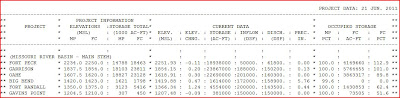
Cave News Dams Report for the Missouri River Reservoir System composted of 6 hydroelectric dams and their large reservoirs (lakes) | June 22, 2011

4- page (this visual is from page #4) Riverwatch June 22, 2011
http://us.vocuspr.com/ViewAttachment.aspx?EID=NMIJ1IcKk3oTji9VTTk54oX4H85Z6zra03rgkvIEC6A%3d

*Note the last of the 6 dams of the Missouri River Reserve System is Gavins Point (dam at bottom) - check out small this dam's reservoir is in comparisons to the dams upstream!! When I was a kid (I'm 61) and grew up around that reservoir - they did NOT keep the "lake" high all year around - they used it as a RESERVOIR not a recreational lake (Federal endangered species is another 'excuse' it has been left high since it was passed in 2003).


DAILY US ARMY CORP OF ENGINEERS RESERVOIR CONTROL CENTER REPORT

http://us.vocuspr.com/ViewAttachment.aspx?EID=NMIJ1IcKk3oTji9VTTk54oX4H85Z6zra03rgkvIEC6A%3d

A guide assisting in reading this report:

  • Under 'Project Information' are the capacities of each reservoir referring to the dam/reservoir's elevation above sea level.
  • MP means the minimum power pool or a normal lake level- FC means flood control of the maximum height the reservoir can hold before water goes over the emergency spillways (called an "uncontrolled release").
  • Current data shows the reservoirs actual level at the time of observation- acre-feet of the lake's surface- inflow to the lake/reservoir and discharge out the dam's control structures/spillway.
  • The last figure in each project- probably the figure most telling- is the percentage of flood control capacity left in that particular reservoir/lake.

http://www.nwo.usace.army.mil/html/Lake_Proj/fortpeck/welcome.html
60200 cubic feet per second (cfs) June 22, 2011
61800 cubic feet per second (cfs) June 21, 2011

percentage of flood control capacity left in that particular reservoir/lake 112.9% June 22, 2011
percentage of flood control capacity left in that particular reservoir/lake 112.9% June 21, 2011
percentage of flood control capacity on JUNE 15, 2011 115.1%

http://www.nwo.usace.army.mil/html/Lake_Proj/garrison/welcome.html
(Minot ND is flooding)
150400 cubic feet per second (cfs) June 22, 2011
150200 cubic feet per second (cfs) June 21, 2011

percentage of flood control capacity left in that particular reservoir/lake
102.4% June 22, 2011
percentage of flood control capacity left in that particular reservoir/lake 101.0% June 21, 2011
percentage of flood control capacity on JUNE 15, 2011 98%

http://www.nwo.usace.army.mil/html/Lake_Proj/oahe/welcome.html
153900 cubic feet per second (cfs) June 22, 2011
160300 cubic feet per second (cfs) June 21, 2011

percentage of flood control capacity left in that particular reservoir/lake 92.7% June 22, 2011
percentage of flood control capacity left in that particular reservoir/lake 89.8% June 21, 2011
percentage of flood control capacity on JUNE 15, 2011 87.8

http://www.nwo.usace.army.mil/html/Lake_Proj/bigbend/welcome.html
162900 cubic feet per second (cfs) June 22, 2011
158900 cubic feet per second (cfs) June 21, 2011

percentage of flood control capacity left that particular reservoir/lake 31.7% June 22, 2011
percentage of flood control capacity left that particular reservoir/lake 0.0% June 21, 2011
percentage of flood control capacity on JUNE 15, 2011 0.0%

http://www.nwo.usace.army.mil/html/Lake_Proj/fortrandall/welcome.html
139600 cubic feet per second (cfs) June 22, 2011
143500 cubic feet per second (cfs) June 21, 2011

percentage of flood control capacity left in that particular reservoir/lake 68.7% June 22, 2011
percentage of flood control capacity left in that particular reservoir/lake 62.4% June 21, 2011
percentage of flood control capacity on JUNE 15, 2011 51.7%

http://www.nwo.usace.army.mil/html/Lake_Proj/gavinspoint/welcome.html
150900 cubic feet per second (cfs) June 22, 2011
150000 cubic feet per second (cfs) June 21, 2011

percentage of flood control capacity left in that particular reservoir/lake 62.8% June 22, 2011
percentage of flood control capacity left in that particular reservoir/lake 51.6% June 21, 2011
percentage of flood control capacity on JUNE 15, 2011 52.3%

Sioux Ctiy Journal | With increase of release to 160,000 cubic foot per minute - a one foot rise is expected

SIOUX CITY -- The U.S. Army Corps of Engineers Tuesday announced that it will increase the water releases at the Gavins Point Dam near Yankton to 155,000 cubic feet per second on Wednesday, June 22, and 160,000 cfs Thursday, June 23. The announcement came during a regularly scheduled call with the agency that controls water flow along the Missouri River.

"Once they started talking 160,000 releases out of Oahe, I figured that at some point that same amount has to come out of Gavins," he said. "We built our levees to 1,100 (feet above sea level). I think the current (river) elevation is 1,095. I guess this will add 6 inches to that.

"But this puts that much more pressure on the levee and that much more current. The 3-inch rain we got last night created some interior drainage issues. Problems crop up. You deal with them."

1-FOOT RISE

Col. Robert Ruch, commander of the corps' Omaha District, said the 10,000 cfs increase from Gavins Point and high tributary rivers will combine to raise the Missouri River level about a foot in Sioux City.

At 7 p.m. Tuesday, the river was at 34.23 feet, above the 30-flood stage. The corps has predicted in recent weeks that the river would peak at 35 to 37 feet at Sioux City.

The river will swell first from the tributary flow, he said, then maintain that level because of the additional Gavins Point discharge.

Despite the increases from Gavins Point, the corps does not plan to increase flows at all of the dams along the river.

Farhat said the current plan calls for a reduction at Fort Randall dam, from 143,000 cfs to 138,000 cfs, and from Oahe Dam, which will be reduced from 160,000 cfs to 150,000 cfs.

Flows will increase at Big Bend Dam, which will discharge 165,000 cfs today and for the next seven to 10 days, Farhat said.

Unlike the past few days, the forecast looks much drier after today. According to the National Weather Service, there's a 50 percent chance of rain today in Sioux City but then little more than a 20 to 30 percent chance of rain through Saturday.

The forecast was similar for cities in western, northeast and Southeast South Dakota.

Read full story:

http://siouxcityjournal.com/news/local/a1/article_764767d1-16aa-5144-84d3-ff3bedaad075.html

Click picture to view video on YouTube

Joyce Riley's Power Hour News | June 21, 2011 - News Concerning Missouri River Flooding


Inches away from being America's Fukushima: Nuclear plant dangerously close to being engulfed by Missouri floods
A nuclear plant was inches away from being engulfed by the bloated Missouri River after several levees in the area failed to hold back its surging waters, raising fears it could become America's Fukushima. Dramatic pictures show the moment the plant was threatened with being shut down today, as water levels rose ominously to within 18 inches of its walls.


Nebraska Public Power District: Nuke Plant Could Be Shut Down “In Three Seconds”, Critics Still Worry
Sandia Labs: Similarities between Fukushima Dai-Ichi and reactors like Nebraska’s Cooper nuke plant pose significant problem — Loss of electricity could cause meltdown.

FEMA Enforces Mandatory Evacuation of Minot, ND
A FEMA release today documents just how bad and/or dangerous this situation is getting in North Dakota (most likely at Garrison Dam and two Nebraska Nuclear Reactor Facilities — one includes a GE Type 4 reactor).

YouTube: Fort Calhoun nuclear plant new Fukushima?
RTAmerica - Much of the mainstream media has passed by the case of a nuclear plant in Nebraska that suffered from a fire two weeks ago. Officials there say it was extinguished in about 20 minutes, but now there is cause for a new concern...

New Policy Holders May Not Be Covered By Flood Insurance

According to the Federal Emergency Management Agency, only policies purchased by May 1, 2011 will cover losses caused by Missouri River flooding triggered by releases from upstream dams.


Joyce discussed in the 1st hour of her radio show issues relating to Ft. Calhoun and Cooper nuclear plants in Nebraska and the following headlines that are up this morning on the DrudgeReport.com. Joyce did a very good job explaining the issue with flood Insurance and this flooding in Minot ND being a MAN MADE flood due to the huge RESERVOIR (called a lake) behind Garrison Dam that is releasing water into South Dakota and and coming down the Missouri River from Montana.

MINOT FLOOD: Disastrous. Unstoppable. Historic. Unprecedented...

12,000 evacuated...

Rage at the Army Corps of Engineers...


Joyce Riley has an archive of her radio programs and I would highly suggest all to listen to the first hour of her Power Hour radio program if you are wanting to learn more about the flooding of the Missouri River. The following is a link to her archives and this program would be June 22nd and the FIRST HOUR (she has a 3 hour radio program each day from 7-10 AM CDT.

http://www.gcnlive.com/programs/powerHour/archives.php
http://www.thepowerhour.com/news.htm

US Army Corp of Engineers will INCREASE release of water from the Missouri River Reservoir System into the river below Yankton, SD by Thursday

KFAB Omaha | Wednesday, June 22, 2011

Output at Gavins Point Dam will increase to 160,000 cubic feet per second by Thursday. Corps officials say the higher releases are a result of continued wet weather throughout the Missouri River Basin. As much as six inches of rain has fallen in parts of South Dakota in the past 48 hours.

The impact of an additional 10,000 cfs will result in an increase in river stages from of seven inches to a foot in Sioux City and three to four inches from Omaha to Rulo, Neb.


Brig. Gen. John McMahon, commander of the Northwestern Division of the Army Corps of Engineers, said "We thought we would be able to hold at 150,000 cfs for an extended period of time. Unfortunately, recent rains have reduced our flexibility, and we must evacuate these flood waters to manage the remaining flood control storage in the reservoir system. He added "as we’ve stated all along, heavy rain storms could result in major revisions.”
http://www.kfab.com/pages/2011Flood.html?article=8738240

Click picture for YouTube Video From Gavins Point Dam with release at 150 cfs (cubic foot per second)

Align Centerhttp://www.youtube.com/watch?v=2rM4aTb42Ao&feature=player_embedded

Click picture for YouTube video of Missouri Levee Spillage taking place downstream from the Missouri River Reservoir ... more flooding to come and won't stop until they say at least August.

http://www.youtube.com/watch?feature=player_embedded&v=RNSJW21iCBg

Tuesday, June 21, 2011

Missouri River Reservoir System - Midnight Elevation Forecast June 21, 2011

**Keeping the reservoir behind the last dam (Gavins Point near Yankton SD) explains why many are VERY upset they have keep this reservoir so full (this is a tiny lake compared to the others!) ... will be accumulating links about endangered fish and birds ....

Riverwatch June 21, 2011 #2011MoRivFloodTuesday, June 21, 2011 2:39 PM


http://us.vocuspr.com/ViewAttachment.aspx?EID=NMIJ1IcKk3oTji9VTTk54uZaeHKKC62iRSiIxYaMDEg%3d