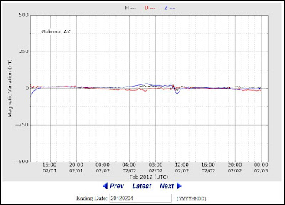
http://www.haarp.alaska.edu/cgi-bin/magnetometer/gak-mag.cgi

The High Frequency Active Auroral Research Program (HAARP) is an ionospheric research program jointly funded by the US Air Force, the US Navy, the University of Alaska and the Defense Advanced Research Projects Agency (DARPA).
HAARP FLUXGATE MAGNETOMETER
http://en.wikipedia.org/wiki/Magnetosphere
A magnetosphere is formed when a stream of charged particles, such as the solar wind, interacts with and is deflected by the intrinsic magnetic field of a planet or similar body. Earth is surrounded by a magnetosphere, as are the other planets with intrinsic magnetic fields: Mercury, Jupiter, Saturn…
Swedish Institute of Space Physics http://www.irf.se/