- M 7.0, Vanuatu
- 2 hours ago
- M 5.8, offshore Bio-Bio, Chile
- 9 hours ago
- M 5.0, South Sandwich Islands region
- 11 hours ago
- M 6.2, South Sandwich Islands region
- 20 hours ago
- M 5.1, Fox Islands, Aleutian Islands, Alaska
- 1 day ago
- M 5.8, Santa Cruz Islands
- 1 day ago
- M 5.1, Halmahera, Indonesia
- 1 day ago
- M 6.7, Santiago del Estero, Argentina
- 1 day ago
- M 6.8, Fox Islands, Aleutian Islands, Alaska
- 1 day ago
- M 5.2, Vanuatu
- 2 days ago
Saturday, September 3, 2011
The Cave's Saturday Evening Earthquake Update - Latest 5+ Magnitude in the World
Latest Earthquakes M5.0+ in the World
CURRENT LASCO C2 and LASCO C3 - Sep 3, 2011 at 7:30 PM CDT
LASCO (Large Angle Spectrometric Coronagraph) is able to take images of the solar corona by blocking the light coming directly from the Sun with an occulter disk, creating an artificial eclipse within the instrument itself. The position of the solar disk is indicated in the images by the white circle. The most prominent feature of the corona are usually the coronal streamers, those nearly radial bands that can be seen both in C2 and C3. Occasionally, a coronal mass ejection can be seen being expelled away from the Sun and crossing the fields of view of both coronagraphs. The shadow crossing from the lower left corner to the center of the image is the support for the occulter disk.
C2 images show the inner solar corona up to 8.4 million kilometers (5.25 million miles) away from the Sun.
C3 images have a larger field of view: They encompass 32 diameters of the Sun. To put this in perspective, the diameter of the images is 45 million kilometers (about 30 million miles) at the distance of the Sun, or half of the diameter of the orbit of Mercury. Many bright stars can be seen behind the Sun.
Source: NASA / ESA / SOHO / LASCO, EIT and MDI teams
MAGNETOSPHERE UPDATE - SEPTEMBER 3, 2011
http://www.youtube.com/user/CaveNews

http://137.229.36.30/cgi-bin/magnetometer/gak-mag.cgi


http://137.229.36.30/cgi-bin/magnetometer/gak-mag.cgi
The High Frequency Active Auroral Research Program (HAARP) is an ionospheric research program jointly funded by the US Air Force, the US Navy, the University of Alaska and the Defense Advanced Research Projects Agency (DARPA).
HAARP FLUXGATE MAGNETOMETER
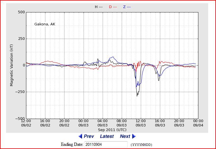
http://en.wikipedia.org/wiki/Magnetosphere
A magnetosphere is formed when a stream of charged particles, such as the solar wind, interacts with and is deflected by the intrinsic magnetic field of a planet or similar body. Earth is surrounded by a magnetosphere, as are the other planets with intrinsic magnetic fields: Mercury, Jupiter, Saturn…
STRONG 7.0 magnitude earthquake hit VANUATU - No Tsunami Expected


http://wcatwc.arh.noaa.gov/2011/09/03/lqyyck/01/messagelqyyck-01.htm
A strong earthquake has occurred, but a tsunami IS NOT expected along the California, Oregon, Washington, British Columbia, or Alaska coast. NO tsunami warning, watch or advisory is in effect for these areas.
Based on the depth of the earthquake within the earth, a tsunami IS NOT expected along the California, Oregon, Washington, British Columbia, and Alaska coasts.
At 3:56 PM Pacific Daylight Time on September 3, an earthquake with preliminary magnitude 7.0 occurred near the Vanuatu Islands at 136km depth. (Refer to the United States Geological Survey for official earthquake parameters.)
Pacific coastal regions outside California, Oregon, Washington, British Columbia, and Alaska should refer to the Pacific Tsunami Warning Center messages for information on the event.
This will be the only statement issued for this event by the West Coast/Alaska Tsunami Warning Center unless conditions warrant. See the WCATWC web site for basic tsunami information, safety rules, and a tsunami travel time map and table. (NOTE: Travel time maps and tables indicate forecasted times only, not that a wave was generated.)


Who's Fracking Now: Got Chemicals? In Your Water? Want to Know?
http://my.auburnjournal.com/detail/186966.html
Oil and gas companies are drilling in California using a controversial method known as "fracking" with hardly any oversight. This leaves your groundwater at risk of potential contamination. We need your voice today to change that.
Fracking is the industry term for hydraulic fracturing, an increasingly infamous method of gas extraction that involves pumping pressured water mixed with a cocktail of industrial chemicals (usually kept secret by drilling companies) into gas wells. This highly controversial, dangerous drilling method has been linked to water contamination in other parts of the country. Recent reports show fracking has resulted in more than 1,000 documented cases of groundwater contamination, either through the leaking of fracking fluids and methane into groundwater or via above ground spills of contaminated waste water.
A common-sense bill -- A.B. 591, introduced by Democratic Assembly member Bob Wieckowski -- would ensure that California's citizens have access to information about fracking in our communities. 591 would require oil and gas companies to disclose -- for the first time -- when and where they're fracking, what chemicals they're using, and how much scarce water their operations consume. All of this information would be published on a public website, setting one of the highest bars for fracking disclosure in the nation.
READ MORE...

Saturday Morning Earthquake Update - Latest 5+ Worldwide
http://earthquake.usgs.gov/earthquakes/recenteqsww/Quakes/quakes_big.php
| MAP | 5.0 | 2011/09/03 14:00:59 | -56.241 | -25.765 | 34.9 | SOUTH SANDWICH ISLANDS REGION |
| MAP | 6.2 | 2011/09/03 04:49:01 | -56.551 | -27.039 | 106.0 | SOUTH SANDWICH ISLANDS REGION |
| MAP | 5.1 | 2011/09/03 01:25:39 | 52.056 | -171.567 | 51.2 | FOX ISLANDS, ALEUTIAN ISLANDS, ALASKA |
| MAP | 5.8 | 2011/09/03 01:06:56 | -12.784 | 166.672 | 101.2 | SANTA CRUZ ISLANDS |
| MAP | 5.1 | 2011/09/02 20:19:02 | 2.724 | 128.519 | 211.2 | HALMAHERA, INDONESIA |
| MAP | 6.7 | 2011/09/02 13:47:11 | -28.422 | -63.146 | 592.8 | SANTIAGO DEL ESTERO, ARGENTINA |
| MAP | 6.8 | 2011/09/02 10:55:54 | 52.185 | -171.684 | 35.5 | FOX ISLANDS, ALEUTIAN ISLANDS, ALASKA |
USGS Geologists map Lassen Volcanic National Park in CA


It took the two geologists and their colleagues at USGS 35 years to produce the Lassen maps. "We've been on top of every bloody peak out there," Muffler said. Age-dating techniques developed in the 1990s enabled the scientists to calculate more precisely how long ago eruptions occurred at various locations in the park.
They've also been able to trace the outlines of the mother of all Lassen volcanoes, the massive Brokeoff Volcano, which dominated the Lassen skyline some 600,000 years ago the same way Mt. Shasta does in its own region today. Over the years Brokeoff was worn down by water and glacial erosion.
The park's current star volcano, Lassen Peak, last erupted in 1915, drawing attention to the volcanic region and spurring its designation the following year as a national park.
Lassen National Park offers "the most spectacular array of thermal features in the Cascade Range," according to the pamphlet that accompanies the new maps. Those spectacular features include the fumaroles, bubbling mud pots, and a boiling lake, Boiling Spring Lake — all evidence of the intense thermal activity just under the surface.
READ MORE:
http://www.redding.com/news/2011/aug/27/men-map-lassens-volcanoes/
RELATED:
http://www.nps.gov/lavo/naturescience/eruption_lassen_peak.htm
READ MORE:
http://www.redding.com/news/2011/aug/27/men-map-lassens-volcanoes/
RELATED:
http://www.nps.gov/lavo/naturescience/eruption_lassen_peak.htm
On May 22, 1915, an explosive eruption at Lassen Peak, the southernmost active volcano in the Cascade Range, devastated nearby areas and rained volcanic ash as far away as 200 miles to the east. This explosion was the most powerful in a 1914-17 series of eruptions that were the last to occur in the Cascades before the 1980 eruption of Mt. St. Helens. Lassen Peak is the largest of a group of more than 30 volcanic domes erupted over the past 300,000 years in Lassen Volcanic National Park.
5.0 Magnitude hits South Sandwich Islands Region

earthquake.usgs.gov
USGS Earthquake Hazards Program, responsible for monitoring, reporting, and researching earthquakes and earthquake hazards

Solar Dynamics Observatory SDO | 48 hr video VISIBLE SUNSPOTS and CORONAL HOLE


A solar wind stream flowing from the indicated coronal hole could reach Earth on Sept. 5-7. Credit: SDO/AIA.
Subscribe to:
Posts (Atom)