

Showing posts with label California. Show all posts
Showing posts with label California. Show all posts
Thursday, September 8, 2011
Sunday, September 4, 2011
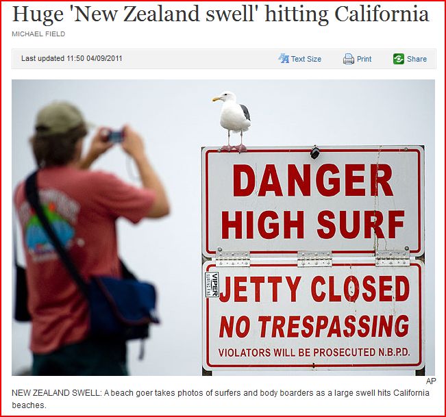
Massive waves hitting California's coast - killing at least one and causing millions of dollars in damage - are being labelled the "New Zealand Surf"
http://www.stuff.co.nz/world/americas/5561650/Huge-New-Zealand-swell-hitting-California
September 4, 2011
Massive waves slamming into California's coast - killing at least one person and causing millions of dollars in damage - are being labelled the "New Zealand surf" because of where they are coming from.
In a rare event, a big weather system between New Zealand and Antarctica has generated a heavy Pacific wide swell, bringing the waves to California.
Sean Collins, chief forecaster and president of Surfline, told news website Patch.com he warned Californian authorities over the swell.
"Extra caution is urged to keep the public aware and safe from these large waves and associated rip currents."
He said it was one of the biggest swells to hit with some waves coming ashore at six to seven metres.
Collins said southern hemisphere storms routinely produced waves in California, but this latest one was in the top 10 percent of known waves.
The US National Weather Service has warned beachgoers were urged to swim only near lifeguard towers - or to stay on the sand.
"Have a good time watching the waves but stay out of the water if you're not experienced," National Weather Service forecaster Eric Boldt said.
The rough surf was caused by the swell from a powerful storm in New Zealand, where it is winter.
"It had 50-foot waves down there when it was going at its peak. The energy came up here," Boldt told the Associated Press.
The heavy surf chewed up the sandy bottom, creating potholes that can dunk unwary swimmers and contributing to dangerous rip currents.
"That probably kills more people in Southern California than any other phenomenon." said Boldt.
One news website said many people went to the coast to look at the relentless armada of waves building up and then smashing down along the shore.
"A winter storm off New Zealand is credited with generating the awe-inspiring swell along the Southern California coast," it reported.


Saturday, September 3, 2011
Who's Fracking Now: Got Chemicals? In Your Water? Want to Know?
http://my.auburnjournal.com/detail/186966.html
Oil and gas companies are drilling in California using a controversial method known as "fracking" with hardly any oversight. This leaves your groundwater at risk of potential contamination. We need your voice today to change that.
Fracking is the industry term for hydraulic fracturing, an increasingly infamous method of gas extraction that involves pumping pressured water mixed with a cocktail of industrial chemicals (usually kept secret by drilling companies) into gas wells. This highly controversial, dangerous drilling method has been linked to water contamination in other parts of the country. Recent reports show fracking has resulted in more than 1,000 documented cases of groundwater contamination, either through the leaking of fracking fluids and methane into groundwater or via above ground spills of contaminated waste water.
A common-sense bill -- A.B. 591, introduced by Democratic Assembly member Bob Wieckowski -- would ensure that California's citizens have access to information about fracking in our communities. 591 would require oil and gas companies to disclose -- for the first time -- when and where they're fracking, what chemicals they're using, and how much scarce water their operations consume. All of this information would be published on a public website, setting one of the highest bars for fracking disclosure in the nation.
READ MORE...
Friday, September 2, 2011

Thursday, September 1, 2011
Saturday, February 13, 2010
4.1 magnitude earthquake with aftershocks hit the GREATER LOS ANGELES AREA, CALIFORNIA - 3 mi S from Redlands, CA - Feb 13 2010

| MAP | 2.5 | 2010/02/13 22:09:03 | 34.008 | -117.185 | 7.5 | GREATER LOS ANGELES AREA, CALIFORNIA |
| MAP | 2.5 | 2010/02/13 21:54:40 | 34.010 | -117.189 | 5.0 | GREATER LOS ANGELES AREA, CALIFORNIA |
| MAP | 4.1 | 2010/02/13 21:39:06 | 34.012 | -117.168 | 2.6 | GREATER LOS ANGELES AREA, CALIFORNIA |
Earthquake Details
| Magnitude | 4.1 |
|---|---|
| Date-Time |
|
| Location | 34.012°N, 117.168°W |
| Depth | 2.6 km (1.6 miles) |
| Region | GREATER LOS ANGELES AREA, CALIFORNIA |
| Distances |
|
| Location Uncertainty | horizontal +/- 0.3 km (0.2 miles); depth +/- 0.5 km (0.3 miles) |
| Parameters | Nph=141, Dmin=6 km, Rmss=0.42 sec, Gp= 32°, M-type=local magnitude (ML), Version=2 |
| Source |
Thursday, February 4, 2010
Large 6.0 magnitude earthquake hits OFFSHORE NORTHERN CALIFORNIA - 36 mi WSW from Ferndale, CA - Feb 4 2010 - 12:20 PM at epicenter
| MAP | 6.0 | 2010/02/04 20:20:22 | 40.431 | -124.929 | 11.2 | OFFSHORE NORTHERN CALIFORNIA |
 Distances
- 56 km (35 miles) WNW (282°) from Petrolia, CA
- 59 km (36 miles) WSW (254°) from Ferndale, CA
- 68 km (42 miles) WSW (256°) from Fortuna, CA
- 76 km (47 miles) WSW (239°) from Eureka, CA
- 363 km (225 miles) NW (306°) from Sacramento, CA
MAINSHOCK
 Magnitude   :   5.95 Mw  (A strong quake)
Time        :   04 Feb 2010   00:20:21 PM, PST
            :   04 Feb 2010   20:20:21 GMT
Coordinates :   40 deg. 25.85 min. N, 124 deg. 55.75 min. W
            :   40.4308 N, 124.9292 W
Depth       :     7.0 miles ( 11.2 km)
Quality     :   Good
Location    :    34 mi. ( 55 km) WNW from Petrolia, CA
            :    47 mi. ( 76 km) WSW from Eureka, CA
Event ID    :   NC 71348851
STRONG AFTERSHOCKS (Magnitude 5 and larger) -
At this time (immediately after the mainshock) the probability of a strong and possibly damaging aftershock IN THE NEXT 7 DAYS is approximately 53 PERCENT
EARTHQUAKES LARGER THAN THE MAINSHOCK -
Most likely, the recent mainshock will be the largest in the sequence. However, there is a small chance (APPROXIMATELY 5 TO 10 PERCENT) of an earthquake equal to or larger than this mainshock in the next 7 days.
WEAK AFTERSHOCKS (Magnitude 3 to 5) -
In addition, approximately 30 to 70 SMALL AFTERSHOCKS are expected in the same 7-DAY PERIOD and may be felt locally.
To: U.S. West Coast, Alaska, and British Columbia coastal regions
From: NOAA/NWS/West Coast and Alaska Tsunami Warning Center
Subject: Tsunami Information Statement issued 02/4/2010 at 12:23PM PST
At 12:20 PM Pacific Standard Time on February 4, an earthquake with preliminary magnitude 6.0 occurred 50 miles/80 Km southwest of Eureka, California.
The magnitude is such that a tsunami IS NOT EXPECTED. However, in coastal areas of intense shaking, locally generated tsunamis can be triggered by underwater landslides. This will be the only WCATWC message issued for this event.
Saturday, January 9, 2010
Large 6.5 magnitude earthquake hit OFF THE COAST OF NORTHERN CALIFORNIA - 22 mi WNW of Ferndale, CA - Sat, Jan 09, 2010 at 04:27 PM at epicenter
| MAP | 6.5 | 2010/01/10 00:27:39 | 40.674 | -124.655 | 16.4 | OFFSHORE NORTHERN CALIFORNIA |


| Date-Time |
|
|---|---|
| Location | 40.674°N, 124.655°W |
| Depth | 16.4 km (10.2 miles) |
| Region | OFFSHORE NORTHERN CALIFORNIA |
| Distances |
|
| Location Uncertainty | horizontal +/- 0.7 km (0.4 miles); depth +/- 1.1 km (0.7 miles) |
| Parameters | Nph= 99, Dmin=35 km, Rmss=0.36 sec, Gp=212°, M-type=regional moment magnitude (Mw), Version=3 |
| Source | |
| Event ID | nc71338066 |
To: U.S. West Coast, Alaska, and British Columbia coastal regions
From: NOAA/NWS/West Coast and Alaska Tsunami Warning Center
Subject: Tsunami Information Statement issued 01/9/2010 at 4:32PM PST
At 4:28 PM Pacific Standard Time on January 9, an earthquake with preliminary magnitude 6.4 occurred 15 miles/24 Km southwest of Eureka, California.
The magnitude is such that a tsunami IS NOT EXPECTED. However, in coastal areas of intense shaking, locally generated tsunamis can be triggered by underwater landslides. This will be the only WCATWC message issued for this event.
The location and magnitude are based on preliminary information. Further information will be issued by the United States Geological Survey or the appropriate regional seismic network.
Link to Standard Information Statement
Link to XML/CAP Message
Link to Printable Message

Friday, January 8, 2010
Why Just About Everything You Hear About California's Water Crisis Is Wrong, Wrong, Wrong

January 8, 2010.
.... The power of simple fact-checking aside, why would California officials exaggerate -- if not outright lie -- about the drought? Well, the issue here is less about the drought itself and more about what a drought -- real or not -- can help achieve. If there is one thing 2009 revealed about California's "action hero" governor, it's that he is eagerly willing to serve as the front man for the sleaziest, most crooked business cartel in the state: a de facto water oligarchy made up of billionaire corporate farmers who run vast stretches of the state like their own personal fiefdoms, exploiting migrant workers for slave labor and soaking the taxpayers for billions of dollars in subsidies every year. And like all good businessmen, they aren't letting a good mini-crisis go to waste. Their objective is to whip up fears of a drought-related calamity to push through a "solution" they've been having wet dreams about for the past five decades: a multi-billion-dollar aqueduct the width of the Panama Canal that would give them near total control of more than half of California's water supplies....
http://www.alternet.org/story/144992/why_just_about_everything_you_hear_about_california%27s_water_crisis_is_wrong%2C_wrong%2C_wrong
Thursday, January 7, 2010
4.1 magnitude earthquake hit the San Francisco Bay area, California - 11 mi NNE from San Jose City Hall, CA - Jan 07, 2010 at 10:09 AM at epicenter
| MAP | 4.1 | 2010/01/07 18:09:35 | 37.477 | -121.797 | 9.0 | SAN FRANCISCO BAY AREA, CALIFORNIA |
 Distances
- 10 km (6 miles) ENE (62°) from Milpitas, CA
- 12 km (8 miles) NNE (12°) from Alum Rock, CA
- 16 km (10 miles) SSE (150°) from Sunol, CA
- 17 km (11 miles) NNE (29°) from San Jose City Hall, CA
Monday, January 4, 2010
Earthquake swarm hits Northern California this morning - 9 mi NNW from Redway, CA - January 4, 2010
| MAG | UTC DATE-TIME y/m/d h:m:s | LAT deg | LON deg | DEPTH km | Region | |
|---|---|---|---|---|---|---|
| MAP | 2.6 | 2010/01/04 15:44:56 | 40.264 | -123.869 | 29.5 | NORTHERN CALIFORNIA |
| MAP | 2.7 | 2010/01/04 14:29:41 | 40.262 | -123.859 | 30.0 | NORTHERN CALIFORNIA |
| MAP | 4.1 | 2010/01/04 14:24:53 | 40.247 | -123.862 | 16.2 | NORTHERN CALIFORNIA |
| MAP | 2.6 | 2010/01/04 14:10:55 | 40.269 | -123.872 | 32.0 | NORTHERN CALIFORNIA |

Wednesday, December 30, 2009
3.3 MAGNITUDE EARTHQUAKE HITS GREATER LOS ANGELES AREA, CALIFORNIA - Wednesday, December 30, 2009 at 04:17:56 PM at epicenter
| MAP | 3.3 | 2009/12/31 00:17:56 | 34.017 | -117.108 | 8.0 | GREATER LOS ANGELES AREA, CALIFORNIA |

| Magnitude | 3.3 |
|---|---|
| Date-Time |
|
| Location | 34.017°N, 117.108°W |
| Depth | 8 km (5.0 miles) |
| Region | GREATER LOS ANGELES AREA, CALIFORNIA |
| Distances |
|
| Source |
Thursday, December 24, 2009
California Governor Schwarzenegger May Appeal to Obama as $21 Billion Deficit Defies Solution...

Dec. 24 (Bloomberg) -- California Governor Arnold Schwarzenegger, anticipating a $21 billion budget deficit, plans to ask President Barack Obama to ease mandates and minimums on social programs to save as much as $8 billion.
The Republican governor plans to seek the relief, according to a California official who asked not to be identified because details haven’t been resolved. Instead of seeking one-time stimulus money or a bailout, the most-populous state wants the U.S. to reduce mandates and waive rules stipulating expenditures on programs such as indigent health care, the official said.
California is among states most affected by the economic recession. It has the lowest credit rating and recorded the nation’s second-highest rate of home foreclosures, trailing only Nevada. Unemployment peaked at 12.5 percent in October amid the loss of 687,700 jobs from the year before, when the jobless figure was 8 percent. Wealth declined as the stock market lost 40 percent of its value in 2008. READ MORE ....
http://www.bloomberg.com/apps/news?pid=20601087&sid=aKc0QT2U7Gc0
Sunday, December 13, 2009
Many 'non-students' demonstrate violently against California state funding cuts leading to course cutbacks, faculty furloughs and sharp fee increases
Neither Mogulof nor Sunshine could say why so many non-students were among those arrested.

Protesters damage Calif. university leader's home. The eight were arrested on suspicion of rioting and several other charges. "Most of what you have here are people from outside the university," Wendy Brown, co-chair of the Berkeley Faculty Association and a professor of political science, said in criticizing the violence.
BERKELEY, Calif. Dec 13, 2009— Demonstrations are against state funding cuts that have led to course cutbacks, faculty furloughs and sharp fee increases. Gov. Arnold Schwarzenegger and the Legislature cut spending for California's two public university systems by 20 percent to help balance the state's budget. Community colleges were cut about 8 percent.
The two incidents are the latest in a series of demonstrations in which students have taken over buildings at California State University and University of California campuses.
"I'm shocked that it happened," said Chengwin Saephanh, a sophomore bioengineering major who earlier participated in two peaceful classroom walkouts. "I'm pretty upset about the fees, but I don't know what the goals are of those who were at the house. I wouldn't go into anything violent, I just participate in the peaceful ones." Agnes Balla, a junior public health major, said she walked out of classes weeks ago and joined peaceful protests that united the campus community and brought attention to a serious problem.
"With this turn of events, that's not what's going on anymore. It's people retaliating against what's going on, and that's not going to bring change," Balla said. "I'm in support of bringing attention to this, but it's gone too far.
"Certainly an event like this doesn't go unnoticed," King said. "We endeavor to keep our people secure, not only for their sake but for the sake of everybody in the community."
"California will not tolerate any type of terrorism against any leaders, including educators," Schwarzenegger said in a statement. "Debate is the foundation of democracy and I encourage protesters to find peaceful and productive ways to express their opinions."
The UC system, with about 220,000 students, raised student fees 15 percent since January and plans another 15 percent increase. The CSU system, the nation's largest with 450,000 students, and the community college system also raised fees.
"Obviously, the faculty don't advocate for violence," said Alice Sunshine, spokeswoman for the California Faculty Association that represents most CSU professors. "We try to steer them into protests that express how to make things better, but I think some of the students are really angry."
"It's a big public issue for the entire state," Sunshine said. "There's wider interest than just the students themselves. The future of higher education in California is at stake."
Police ended the occupation of the campus's Wheeler Hall earlier Friday. They arrested 65 people inside on misdemeanor trespassing charges, including about 24 who were not students, Mogulof said. One person was arrested outside the hall on suspicion of inciting.
The two incidents are the latest in a series of demonstrations in which students have taken over buildings at California State University and University of California campuses.
"I'm shocked that it happened," said Chengwin Saephanh, a sophomore bioengineering major who earlier participated in two peaceful classroom walkouts. "I'm pretty upset about the fees, but I don't know what the goals are of those who were at the house. I wouldn't go into anything violent, I just participate in the peaceful ones." Agnes Balla, a junior public health major, said she walked out of classes weeks ago and joined peaceful protests that united the campus community and brought attention to a serious problem.
"With this turn of events, that's not what's going on anymore. It's people retaliating against what's going on, and that's not going to bring change," Balla said. "I'm in support of bringing attention to this, but it's gone too far.
"Certainly an event like this doesn't go unnoticed," King said. "We endeavor to keep our people secure, not only for their sake but for the sake of everybody in the community."
"California will not tolerate any type of terrorism against any leaders, including educators," Schwarzenegger said in a statement. "Debate is the foundation of democracy and I encourage protesters to find peaceful and productive ways to express their opinions."
The UC system, with about 220,000 students, raised student fees 15 percent since January and plans another 15 percent increase. The CSU system, the nation's largest with 450,000 students, and the community college system also raised fees.
"Obviously, the faculty don't advocate for violence," said Alice Sunshine, spokeswoman for the California Faculty Association that represents most CSU professors. "We try to steer them into protests that express how to make things better, but I think some of the students are really angry."
"It's a big public issue for the entire state," Sunshine said. "There's wider interest than just the students themselves. The future of higher education in California is at stake."
Police ended the occupation of the campus's Wheeler Hall earlier Friday. They arrested 65 people inside on misdemeanor trespassing charges, including about 24 who were not students, Mogulof said. One person was arrested outside the hall on suspicion of inciting.
http://www.google.com/hostednews/ap/article/ALeqM5hBNLRiW12YKk2nY7vbCwE_pYzLnwD9CI3JG00
Cave Editor's Note: Follow the above link and see what corporate-government media wanted the populous to see ... violent protests vs their own facts of involvement by violent non-students
This is an example of:
GOVERNMENT PAID PROVOCATEURS
KEEPING THE ATTENTION ON VIOLENT PROTESTS and DISTRACTION FROM FROM THE CORE ISSUES
KEEPING THE ATTENTION ON VIOLENT PROTESTS and DISTRACTION FROM FROM THE CORE ISSUES
As I frequently say - read the whole article - especially the last couple paragraphs because that is where the government-corporate media sticks what they DON'T want the public to realize.
The government-corporate media is in the business of DISTRACTING the public from the looting and pillaging of our nation by globalist banksters and their multinational corporations.
The government-corporate media is in the business of DISTRACTING the public from the looting and pillaging of our nation by globalist banksters and their multinational corporations.
Wednesday, December 9, 2009
Santa Clara County, California - leading provider of homeless services - held a Memorial for the 67 Men and Women that died on the streets this year
 SANTA CLARA COUNTY, CA (KGO) -- December 9, 2009 - Santa Clara County's leading provider of homeless services held a memorial Wednesday for the 67 men and women it says have died on the county's streets this year.
EHC Lifebuilders says about half the homeless were killed by harsh weather. The rest are victims of cruel fate.
"We have folks who die by being hit by cars, murder... It's a wide variety of reasons, certainly folks who are homeless have compromised health," said Jenny Nicklaus.
Lifebuilders also says that because of an increase in shelter space, there was a 20 percent decrease in the number of homeless deaths in Santa Clara County in 2009, 66, compared to 82 in 2008.
Source:
http://abclocal.go.com/kgo/story?section=news/local/south_bay&id=7162344
Tuesday, November 17, 2009
Washington Examiner | Forget jobs summit: Turn on California's water
For Fresno and California's entire Central Valley, it should be the best of times.
With the dollar weak and the world hungry, the exceptionally fertile fields along the Golden State highway should be producing record yields of grains, fruits, vegetables and nuts.
Instead framers are struggling to keep even a third of their potential acreage in use. Mile after mile of parched land greets the approach to the city of 500,000. And angry signs along the roadside condemn the federal government that has cut off the valley's water.
The delta smelt, a small fish that makes its home in the vast Sacramento Delta, has been declared endangered. Since late last year the water lifeline from the north to the south has been reduced to a trickle.
The pumps that power the water to the farms have been stilled for months at a time so as to avoid sucking in smelt. The smelt's numbers have been reduced by many causes, but the one the federal government has decided to target is the pumps.
When Washington, D.C., ordered the water shut off, jobs went down the drain. Tens of thousands of farm jobs have been lost, and unemployment in some farming towns has hit 40 percent.
Secretary of the Interior Ken Salazar and Sen. Dianne Feinstein, D-Calif., posture about their concern (Sen. Barbara Boxer, D-Calif., can't even be bothered to meet with local officials), and the region's Democratic congressmen like Reps. Dennis Cardoza and Jim Costa pledge action, but the president, his senior officials and congressional allies have done nothing. A new, man-made dust bowl is taking shape, and the devastation is palpable. FULL STORY>>>>
Monday, November 16, 2009
LA Times | 3.6 earthquake hits Riverside County (California) area, Southland's third in a day
November 16, 2009 - A magnitude 3.6 earthquake hit Riverside County east of Temecula.
The temblor did not cause any damage, though it was felt in parts of the Inland Empire. It hit near the small town of Anza in southwestern Riverside County.
It was the third moderate quake to hit Southern California in the last 24 hours. A 4.3 temblor hit off San Nicholas Island Sunday afternoon, followed by a 3.6 aftershock.
Neither of those quakes caused damage or injuries.
RELATED:

| MAG | UTC DATE-TIME y/m/d h:m:s | LAT deg | LON deg | DEPTH km | Region | |
|---|---|---|---|---|---|---|
| MAP | 3.6 | 2009/11/16 13:54:33 | 33.415 | -116.642 | 5.1 | SOUTHERN CALIFORNIA |
| MAP | 2.6 | 2009/11/16 01:34:33 | 37.458 | -118.840 | 7.7 | CENTRAL CALIFORNIA |
| MAP | 3.6 | 2009/11/15 22:48:37 | 33.172 | -119.302 | 6.0 | CHANNEL ISLANDS REGION, CALIFORNIA |
| MAP | 4.4 | 2009/11/15 22:45:27 | 33.166 | -119.302 | 6.0 | CHANNEL ISLANDS REGION, CALIFORNIA |
| MAP | 3.3 | 2009/11/15 07:54:22 | 33.915 | -117.055 | 9.6 | SOUTHERN CALIFORNIA |
| MAP | 3.2 | 2009/11/13 13:22:37 | 38.992 | -111.392 | 0.5 | UTAH |
| MAP | 3.3 | 2009/11/13 10:11:37 | 34.164 | -117.427 | 5.5 | GREATER LOS ANGELES AREA, CALIFORNIA |
| MAP | 2.9 | 2009/11/12 07:41:05 | 33.839 | -116.844 | 14.9 | SOUTHERN CALIFORNIA |
| MAP | 2.5 | 2009/11/11 05:56:41 | 35.427 | -116.762 | 5.0 | SOUTHERN CALIFORNIA |
| MAP | 3.6 | 2009/11/11 03:24:23 | 33.248 | -116.052 | 3.9 | SOUTHERN CALIFORNIA |
| MAP | 2.8 | 2009/11/09 20:35:16 | 34.693 | -116.302 | 5.5 | SOUTHERN CALIFORNIA |
Sunday, November 15, 2009
USGS | Quakes measuring 4.3 and 3.6 magnitude hit the CHANNEL ISLAND REGION, CALIFORNIA - Sunday, November 15, 2009

| MAG | UTC DATE-TIME y/m/d h:m:s | LAT deg | LON deg | DEPTH km | Region | |
|---|---|---|---|---|---|---|
| MAP | 3.6 | 2009/11/15 22:48:38 | 33.221 | -119.282 | 5.7 | CHANNEL ISLANDS REGION, CALIFORNIA |
| MAP | 4.3 | 2009/11/15 22:45:27 | 33.165 | -119.302 | 6.0 | CHANNEL ISLANDS REGION, CALIFORNIA |
Wednesday, November 11, 2009
Sacramento Bee | California recycling not as green as would seem
Near Mark Oldfield's desk at the California Department of Conservation sits a ream of copy paper that is more than a routine office commodity. Made in part from recycled fiber, it is a symbol of the state's green spirit. There is a dark side to those sheets of bright, white paper: the part that isn't recycled comes from trees logged in the biologically rich but endangered forests of Indonesia.......
Subscribe to:
Posts (Atom)