| Sand shortage causes concern for flood fighters June 20, 2011 - ST. JOSEPH, Mo. – The supply of sand used to fill hundreds of thousands of bags needed to fight off the swollen Missouri River is running low after weeks of relentless flooding. It's a problem that could get worse as the river is expected to remain high through August, making it unsafe to gather sand from the easiest place to get it: the river itself. Missouri River flood closes 100 miles of bridges June 20, 2011- (Reuters) - Drivers trying to cross from south  east Nebraska into Missouri and Iowa on Monday found bridges closed for more than 100 miles for safety reasons due to flooding and heavier water flows on the Missouri River. east Nebraska into Missouri and Iowa on Monday found bridges closed for more than 100 miles for safety reasons due to flooding and heavier water flows on the Missouri River.Radioactive tritium has leaked from 75% of U.S. nuke plants — Drinking wells were contaminated in Illinois and Minnesota BRACEVILLE, Ill. (AP) - Radioactive tritium has leaked from three-quarters of U.S. commercial nuclear power sites, often into groundwater from corroded, buried piping, an Associated Press investigation shows. US nuke regulators weaken safety rules LACEY TOWNSHIP, N.J. (AP) — Federal regulators have been working closely with the nuclear power industry to keep the nation's aging reactors operating within safety standards by repeatedly weakening those standards, or simply failing to enforce them, an investigation by The Associated Press has found. ‘Event’ at Cooper nuke plant: Oil released into Missouri River after levees over topped June 20, 2011 "Notification is being made to the Nebraska Department of Environmental Quality regarding the release of oil to the Missouri River from the Cooper Live Fire Training Facility. Currently, levees separating the Training Facility and the Missouri River are being over topped due to flooding of the Missouri River... |

Tuesday, June 21, 2011
Joyce Riley's Power Hour News | June 21, 2011 - News Concerning Missouri River Flooding


Monday, June 20, 2011
Earthquake Update | June 20, 2011 at 7:45 PM CDT
Update time = Tue Jun 21 0:21:40 UTC 2011
| | MAG | UTC DATE-TIME y/m/d h:m:s | LAT deg | LON deg | DEPTH km | Region |
|---|---|---|---|---|---|---|
| MAP | 4.9 | 2011/06/20 23:09:36 | 39.163 | 146.351 | 15.1 | OFF THE EAST COAST OF HONSHU, JAPAN |
| MAP | 4.8 | 2011/06/20 22:05:52 | -4.505 | 135.518 | 13.0 | NEAR THE SOUTH COAST OF PAPUA, INDONESIA |
| MAP | 5.5 | 2011/06/20 18:13:22 | -13.341 | 167.171 | 210.7 | VANUATU |
| MAP | 6.5 | 2011/06/20 16:36:01 | -21.681 | -68.187 | 127.1 | ANTOFAGASTA, CHILE |
| MAP | 2.7 | 2011/06/20 14:07:05 | 35.058 | -120.406 | 0.5 | CENTRAL CALIFORNIA |
| MAP | 2.5 | 2011/06/20 12:58:55 | 18.620 | -66.849 | 81.8 | PUERTO RICO REGION |
| MAP | 4.4 | 2011/06/20 11:25:54 | 4.686 | -82.580 | 10.0 | SOUTH OF PANAMA |
| MAP | 3.1 | 2011/06/20 10:53:09 | 60.048 | -152.283 | 87.1 | SOUTHERN ALASKA |
| MAP | 5.3 | 2011/06/20 10:16:55 | 25.069 | 98.707 | 35.2 | MYANMAR-CHINA BORDER REGION |
| MAP | 4.9 | 2011/06/20 06:27:18 | 30.595 | 79.352 | 13.1 | UTTARANCHAL, INDIA |
| MAP | 4.8 | 2011/06/20 03:27:33 | -15.257 | -173.570 | 117.6 | TONGA |
| MAP | 2.5 | 2011/06/20 02:29:46 | 60.353 | -147.663 | 9.8 | SOUTHERN ALASKA |
| MAP | 4.7 | 2011/06/20 01:46:36 | 35.403 | 140.848 | 31.2 | NEAR THE EAST COAST OF HONSHU, JAPAN |


South Dakota Governor forms team to question the US Army Corp of Engineers regarding Missouri River Flooding
KTIV Sioux City Iowa
Corp of Engineers up releases at Oahe Dam at Pierre SD
The Missouri River is flooded in several states. But upstream in Pierre, South Dakota, the Army Corps announced it'll raise releases at the Oahe Dam another 10,000 cubic feet per second this weekend. That will bring it to 160,000 by Sunday.
"We are transferring flood storage from Oahe and Big Bend to Fort Randall, which has more storage available at this time," said Jody Farhat, chief of Water Management, U.S. Army Corps of Engineers, Northwestern Division. "The amount of rain has nearly filled the reservoirs, doing away with most of the flexibility we had built into our operations for this year," said Farhat.
The additional volume will be stored at Fort Randall, with the releases at Fort Randall and Gavins Point remaining at 150,000 cfs. Flows from the Fort Peck and Garrison dams will remain the same, based on current forecast, at 65,000 cfs and 150,000 cfs, respectively.
South Dakota Governor Dennis Daugaard says he is very disappointed by the news.
He says he's concerned and the state is working with the Corps to learn the impact this will have on levees downstream.
Daugaard has named two of his advisers to lead a team that will question the Corps and examine the management decisions that contributed to the flood.
With the initial work complete, the governor says the time has come to ask the Corps why this happened and determine if we can prevent it from happening again.
http://www.ktiv.com/story/14933183/corps-bumps-up-releases-at-oahe-dam-at-pierre
SolarCycle24.com | SOLAR Update for June 20, 2011

Solar Update - A small CME took place on Sunday and was caused by a C-Class flare centered around Region 1237. A very small portion of the expanding cloud may be earth directed. I do not expect much in the way geomagnetic storming.
Sunspot 1234 continues to rotate onto the western limb and 1236 produces the odd C-Class flare as it transits the northern hemisphere. A new sunspot is forming just to the east of 1236 on Monday.
Nuclear Regulary Commission Blog | Fort Calhoun nuclear power plant in Nebraska: Rumors and the Rising River
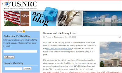
NRC is augmenting its resident inspector staff to provide around the clock coverage at the site. In addition to the two resident inspectors permanently assigned there, four other NRC officials have been sent to site. This includes three inspectors and the chief of the branch overseeing the plant. A roster of other inspectors has been drawn up from which additional inspectors can be dispatched if the need arises.... more
http://public-blog.nrc-gateway.gov/2011/06/17/rumors-and-the-rising-river/

Missouri River expanding ACROSS from Cargil (Calhoun nuclear plant is located next door)

The above screenshot is taken from:
http://www.enterprisepub.com/news/flood_coverage_2011/june-aerial-photos/collection_3d6605b2-984d-11e0-a279-001a4bcf6878.html
CAVE EDITOR NOTE:
This picture is taken from the local newspaper wherein the editor is a pilot and I would recommend those interested in dynamite pictures of the flooding would visit and support his newspaper and subscribing to see his past photographs and articles regarding this flooding that will be going on for months.
Rapid City SD - Complaints of US Army Corp of Engineer's mismanagement of Upper Missouri River
 http://www.rapidcityjournal.com/news/article_224526f0-9af5-11e0-84b8-001cc4c03286.html
Corps caught in the middle
Severe flooding on the upper Missouri may be a rare event, but harsh criticism of the corps isn't. For decades, stakeholders up and down the river have ...
Rapid City Journal
US ARMY CORP OF ENGINEERS ACCUSED OF MISMANAGING THE MISSOURI RIVER
Nebraska Republican Senate hopeful Don Stenberg today is accusing the Army Corps of Engineers of mismanaging the Missouri River and called for Congressional hearings into the Corp of Engineer's actions.
http://nebraska.watchdog.org/14941/flood-of-2011-enters-senate-race-2012/
http://nebraska.watchdog.org/14941/flood-of-2011-enters-senate-race-2012/
Saturday, June 18, 2011


Friday, June 17, 2011


Thursday, June 16, 2011


Wednesday, June 15, 2011

Tuesday, June 14, 2011


Monday, June 13, 2011


Sunday, June 12, 2011


Saturday, June 11, 2011


Friday, June 10, 2011


Thursday, June 9, 2011


Wednesday, June 8, 2011


Tuesday, June 7, 2011


Subscribe to:
Posts (Atom)