Monday, June 27, 2011

Monday June 27, 2011 - MISSOURI RIVER 2011 FLOODING UPDATE (Updated throughout the day)

Omaha.com Monday June 27, 2010

Read more …

Also:


http://www.omaha.com/


Sioux City Journal Monday June 27, 2010


NRC Activates Incident Response Center for Tracking Events at the Fort Calhoun Nuclear Power Plant (pdf) Sunday June 26, 2011


Published
Jun 26, 2011 by AssociatedPress

The chairman of the Nuclear Regulatory Commission says utilities running both of Nebraska's nuclear plants appear to be doing a good job battling Missouri River floodwaters. (June 26)


Reuters | Floodwaters surround Ft. Calhoon nuke plant after breach due to tear in inflatable berm Sunday June 26, 2011


WASHINGTON | Sun Jun 26, 2011 6:03pm EDT

(Reuters) - A tear on Sunday in a temporary berm allowed Missouri River flood waters to surround containment buildings and other vital areas of a Nebraska nuclear plant, but reactor systems were not affected.

The Nuclear Regulatory Commission (NRC) said the breach in the 2,000-foot inflatable berm around the Fort Calhoun station occurred around 1:25 a.m. local time.

More than 2 feet of water rushed in around containment buildings and electrical transformers at the 478-megawatt facility located 20 miles north of Omaha.

Reactor shutdown cooling and spent-fuel pool cooling were unaffected, the NRC said.

The plant, operated by the Omaha Public Power District, has been off line since April for refueling.

Crews activated emergency diesel generators after the breach, but restored normal electrical power by Sunday afternoon, the NRC said.

Buildings at the Fort Calhoun plant are watertight, the agency said. It noted that the cause of the berm breach is under investigation.

NRC Chairman Gregory Jaczko and other officials planned to visit the site on Monday.

Jaczko will also visit the Cooper Nuclear Station near Brownville, Nebraska, another facility that has been watched closely with Missouri River waters rising from heavy rains and snow melt.

But water levels in that area 80 miles south of Omaha are receding, relieving worries that water will rise around the Brownville plant.

http://www.reuters.com/article/2011/06/26/us-usa-nuclear-plant-idUSTRE75P21X20110626

RELATED:

Residents shrug off risk...


Video: Minot ND Flood 2011


Video: Flooding on the Missouri 6-23-2011 from Bismarck, North Dakota to the Garrison Dam


Aerial video of the Missouri River flood taken June 24, 2011

NC News Press - Nebraska City, Nebraska
Near Brownville's Cooper Nuclear Plant


Another river levee fails in northwest Missouri near Cooper Nuclear Plant
Friday, June 24, 2011


FROM DRUDGE REPORT: Sunday June 26, 2011


Drilling For Water Removal At Omaha's Eppley Airfield
Eight sink wells installed for pumps to remove floodwater


REAL TIME RADIATION NETWORK

(The following is only a picture of the website - a link)

http://radiationnetwork.com/

ALERT LEVEL = 100 CPM
CPM = Counts Per Minute

From Radiation Network: The numbers represent radiation Counts per Minute, abbreviated CPM, and under normal conditions, quantify the level of background radiation, i.e. environmental radiation from outer space as well as from the earth's crust and air. Depending on your location, your elevation or altitude, and your model of Geiger counter, this background radiation level might average anywhere from 5 to 60 CPM, and while background radiation levels are random, it would be unusual for those levels to exceed 100 CPM. Thus, the "Alert Level" for the National Radiation Map is 100 CPM, so if you see any Monitoring Stations with CPM value above 100, further indicated by an Alert symbol over those stations, it probably means that some radioactive source above and beyond background radiation is responsible.


NOAA Advanced Hydrologic Prediction Service


BLAIR, NEBRASKA NEAR FT. CALHOUN NUCLEAR POWER PLANT


BROWNVILLE, NE - NEAR COOPER NUCLEAR PLANT


RESERVOIR CONTROL CENTER REPORTS

The following is the latest Reservoir Readings on the Upper Missouri River - Sunday June 26, 2011. This report is updated daily. Click on the picture for today's readings in reference to Gavins Point Dam, Ft. Randall Dam in SD, Big Bend Dam in SD, Oahe Dam in SD, Garrison Dam in ND and Fort Peck in Mt:

Link to daily report:
http://www.nwd-mr.usace.army.mil/rcc/reports/showrep.cgi?3MRDTAP7

Sunday June 26, 2011


US ARMY CORP OF ENGINEERS NEWS RELEASE

July 7, 2011 is scheduled for diversion through regulating tunnels to allow for routine inspection of spillway slabs at Ft. Randall Dam (dam upstream from Gavins Point)

Pickstown, S.D. —The U.S. Army Corps of Engineers invites the public to witness the diversion of surplus water out of Fort Randall Dam through the dam’s four regulating tunnels July 7, between 10 a.m. and 2 p.m.

“This is only the second time in history that such a high volume of water will be released through the regulating tunnels,” said Tom Curran, Fort Randall Dam operations manager.

The opening of the regulating tunnels will equate to a flow of approximately 120,000 cubic feet per second (cfs) through these 22-foot diameter pipes. The water will be diverted to allow for routine inspection of the spillway slab at the dam. The spillway slab is 40 acres of concrete with a thickness of 2 – 6 feet, used to carry water downstream and away from the spillway gates.

Members of the public are invited to witness this event and will be allowed special access to a viewing platform immediately adjacent to the outlet area. Cameras will be permitted.
http://www.nwo.usace.army.mil/html/pa/pahm/NewsReleases11/Public invited to witness historic event at Fort Randall Dam.pdf


Burlington Northern Santa Fe (BNSI) impacted by flooding Missouri River


BNSF Weather Interruptions

June 24, 2011 - BNSF's Command Center is managing our responses to flood impacts. BNSF is making an extraordinary effort to continue operating on key mainline routes.

  • KO subdivision – Both main tracks in Minot, North Dakota are out of service due to record flooding on the Souris River. In a proactive effort to minimize delays, BNSF began rerouting trains prior to the track outage.
  • Creston subdivision – BNSF raised the height of four miles of track up to five feet between Pacific Jct., Iowa and Oreapolis, Nebraska, raised the track on three bridges, built levees along both sides of the track and armored portions of the roadbed with rip rap (boulder-size rock.)
  • The St. Joseph subdivision - BNSF also raised 3.4 miles of track up to 20 inches near Rulo, Nebraska but the subdivision is now is out of service due to flooding near Rulo as a result of a levee break.
  • The River subdivision is out of service south of St. Louis, Missouri due to flooding.
  • The Napier subdivision is out of service between Napier, Missouri and Pacific Jct., Iowa after a levee break near Hamburg, Iowa.
  • The Omaha subdivision is out of service from milepost 13 in Omaha south to milepost 7 as a result of flood levees erected over the track to protect the City of Omaha. The subdivision is still open from Lincoln to Omaha via Ashland, Nebraska.
  • The Choteau subdivision is out of service west of Power, Montana.
  • The Big Sandy subdivision is out of service south of Pacific Jct., Montana.
  • The Fort Benton subdivision is out of service northeast of Great Falls, Montana.
  • The Lewistown subdivision is out of service east of Sipple, Montana due to a washout.
  • The Grenora subdivision is out of service north of Stanley, North Dakota.
  • The Westhope sub is out of service north of Rugby, North Dakota.

http://www.bnsf.com/customers/weather-interruptions/


Video of Approach over flooded Missouri River to Omaha's Eppley Airfield


*Cave Editor's Note:
Last update time
6:45 AM CDT Monday June 27, 2011
Update 8:15 AM CDT

Sunday, June 26, 2011

Magnetosphere Update - June 26, 2011

http://www2.nict.go.jp/y/y223/simulation/realtime/index.html

CAVE NEWS YOU TUBE CHANNEL
DAILY SINCE DECEMBER, 2009


http://www.youtube.com/user/CaveNews?feature=mhum


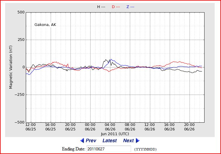
ALASKA'S HAARP FLUXGATE MAGNETOMETER
http://137.229.36.30/cgi-bin/magnetometer/gak-mag.cgi


EARTHQUAKE UPDATE


Latest Earthquakes Magnitude 2.5 or Greater in the United States and Adjacent Areas and Magnitude 4.5 or Greater in the Rest of the World - Last 7 days


Update time = Mon Jun 27 0:00:02 UTC 2011


MAG UTC DATE-TIME
y/m/d h:m:s
DEPTH
km
Region
MAP 4.4 2011/06/26 23:27:47 360.8 KEPULAUAN BARAT DAYA, INDONESIA
MAP 2.5 2011/06/26 20:10:21 64.3 KENAI PENINSULA, ALASKA
MAP 4.7 2011/06/26 20:03:04 21.2 NEAR THE NORTH COAST OF PAPUA, INDONESIA
MAP 5.1 2011/06/26 19:47:01 37.3 EASTERN IRAN
MAP 2.9 2011/06/26 17:24:03 11.4 ISLAND OF HAWAII, HAWAII
MAP 3.3 2011/06/26 16:07:57 38.1 BAJA CALIFORNIA, MEXICO
MAP 4.3 2011/06/26 15:57:07 10.0 NEAR THE NORTH COAST OF PAPUA, INDONESIA
MAP 5.4 2011/06/26 15:03:21 9.4 NEAR THE NORTH COAST OF PAPUA, INDONESIA
MAP 4.5 2011/06/26 14:52:18 10.0 KEPULAUAN TALAUD, INDONESIA
MAP 4.7 2011/06/26 13:19:14 16.2 TAIWAN
MAP 5.0 2011/06/26 12:51:46 29.7 NEAR THE NORTH COAST OF PAPUA, INDONESIA
MAP 5.4 2011/06/26 12:26:32 30.2 NEAR THE NORTH COAST OF PAPUA, INDONESIA
MAP 3.4 2011/06/26 12:23:10 25.3 FOX ISLANDS, ALEUTIAN ISLANDS, ALASKA
MAP 6.4 2011/06/26 12:16:39 20.6 NEAR THE NORTH COAST OF PAPUA, INDONESIA
MAP 4.7 2011/06/26 10:11:38 56.7 NEAR THE EAST COAST OF HONSHU, JAPAN
MAP 4.7 2011/06/26 09:30:03 91.3 PAGAN REGION, NORTHERN MARIANA ISLANDS
MAP 5.5 2011/06/26 09:19:48 97.3 PAGAN REGION, NORTHERN MARIANA ISLANDS
MAP 3.1 2011/06/26 08:56:30 0.1 SOUTHERN CALIFORNIA
MAP 5.3 2011/06/26 07:48:16 24.8 SOUTHERN QINGHAI, CHINA
MAP 3.6 2011/06/26 07:21:47 44.2 FOX ISLANDS, ALEUTIAN ISLANDS, ALASKA
MAP 4.1 2011/06/26 03:03:31 107.4 SOUTHERN ALASKA
MAP 2.7 2011/06/26 02:15:25 7.3 PUERTO RICO REGION
MAP 3.0 2011/06/26 01:05:37 160.1 MONA PASSAGE, DOMINICAN REPUBLIC
MAP 4.4 2011/06/26 00:31:22 27.6 TAIWAN
MAP 4.7 2011/06/26 00:08:12 98.5 SOUTHERN PERU


https://blogger.googleusercontent.com/img/b/R29vZ2xl/AVvXsEi-STGU330TIVW_lYfEGVaZIOfl2Na0qlEGn8Kqx-Uhvv437BBpJNtPpWKMRrfrSuG8OnsFf1ukWDFFwO2klAnJOZNXUCwa00psu8h9dL5oOcQYgTAy5o1Lr3OF1Vt3lCVCKPI2pBbVpT89/s1600/Capture.JPG
New Madrid Center for Earthquake Research and Information


RECENT CENTRAL STATES EARTHQUAKES

map 2.0  2011/06/26     2 km ( 2 mi) E   of Greenbrier, AR 
map 1.6 2011/06/25 6 km ( 4 mi) ESE of Caraway, AR
map 2.4 2011/06/25 8 km ( 5 mi) NNW of Maypearl, TX


SOLAR UPDATE


Solar Update: Solar activity was very low on Saturday with no major flare activity taking place. All current sunspots are in a state of decay.


MOON UPDATE

Reservoir drops at Gavins Point Dam near Yankton SD as record discharge continues - as corp manages space in 5 Missouri River System dams upstream

SiouxCityjournal.com | Posted: Sunday, June 26, 2011 1:39 pm

YANKTON, S.D. - The reservoir at Gavins Point Dam dropped a half-foot in the past 24 hours the dam near Yankton continues to discharge record releases from the Missouri River.

The U.S. Army Corps of Engineers announced today the elevation of the pool at Gavins Point Dam was 1205.9 feet at midnight today, down .5 feet from midnight Saturday. The pool is currently about four feet shy of the top of the spillway gates, which are at 1210 feet.

The change to Gavins Point's reservoir level was the biggest drop in any of the six dams upstream of Sioux City, according to figures the U.S. Army Corps of Engineers released this morning.

Water levels also declined a tenth of a foot behind Fort Peck Dam in eastern Montana and fourth-tenths of a foot at Big Bend Dam near Fort Thompson, S.D. They increased six-tenths of a foot at Fort Randall Dam west of Wagner, S.D., three-tenths of a foot at Oahe Dam near Pierre, S.D., and a tenth of a foot at Garrison Dam near Riverdale, N.D.

Heavy rains early last week spurred the release of 160,000 cubic feet per second from the dam. Previously, the corps had planned to restrict peak releases to 150,000 cfs.

In the week since the increase, corps officials said although they planned to hold releases at 160,000 cfs, reservoirs behind the six dams are nearly full and have little storage space left. Lack of space meant the system was vulnerable to showers and thunderstorms, which officials said could result additional releases from the dams.

The corps modified releases from the dams, increasing flow rates from some while reducing discharge from others, in order to manage what space there is and reduce the pool levels behind some of the dams.

In particular, they reduced outflows from Fort Randall Dam to lower the pool level at Gavins Point. They also restricted flows from the Oahe Dam to because of high flows from the Bad River and increased discharges from Big Bend Dam.

Jody Farhat, chief of the corps Missouri River Water Management, told reporters last week that reservoir levels should begin to decline early this week. More room in the reservoirs would give the corps more flexibility should heavy rains occur, she said.

"Until we gain a couple feet of capacity in these reservoirs, heavy rain will likely result in those increases," Farhat said Thursday.

Read more:
http://www.siouxcityjournal.com/news/local/article_cbfdf9a0-a023-11e0-812c-001cc4c03286.html#ixzz1QQEi1z5o

Reuters | Floodwaters surround Ft. Calhoon nuke plant after breach due to tear in inflatable berm


WASHINGTON | Sun Jun 26, 2011 6:03pm EDT

(Reuters) - A tear on Sunday in a temporary berm allowed Missouri River flood waters to surround containment buildings and other vital areas of a Nebraska nuclear plant, but reactor systems were not affected.

The Nuclear Regulatory Commission (NRC) said the breach in the 2,000-foot inflatable berm around the Fort Calhoun station occurred around 1:25 a.m. local time.

More than 2 feet of water rushed in around containment buildings and electrical transformers at the 478-megawatt facility located 20 miles north of Omaha.

Reactor shutdown cooling and spent-fuel pool cooling were unaffected, the NRC said.

The plant, operated by the Omaha Public Power District, has been off line since April for refueling.

Crews activated emergency diesel generators after the breach, but restored normal electrical power by Sunday afternoon, the NRC said.

Buildings at the Fort Calhoun plant are watertight, the agency said. It noted that the cause of the berm breach is under investigation.

NRC Chairman Gregory Jaczko and other officials planned to visit the site on Monday.

Jaczko will also visit the Cooper Nuclear Station near Brownville, Nebraska, another facility that has been watched closely with Missouri River waters rising from heavy rains and snow melt.

But water levels in that area 80 miles south of Omaha are receding, relieving worries that water will rise around the Brownville plant.

http://www.reuters.com/article/2011/06/26/us-usa-nuclear-plant-idUSTRE75P21X20110626

RELATED:

Residents shrug off risk...

THE CAVE NEWS FLOODING UPDATE - Sunday June 26, 2011 (updated throughout the day)

Video: Flooding on the Missouri 6-23-2011 from Bismarck, North Dakota to the Garrison Dam


Aerial video of the Missouri River flood taken June 24, 2011

NC News Press - Nebraska City, Nebraska
Near Brownville's Cooper Nuclear Plant


Raw footage taken from an airplane on June 23rd, 2011 of the Gavins Point Dam, Yankton SD, Dakota Dunes region of the Missouri River.

Dam footage begins at 5:20, And this is 160,000 cubic feet/sec


EMERGENCY NOW DECLARED FOR 4 NORTHEAST KANSAS COUNTIES DUE TO RISING MISSOURI RIVER

Posted on Fri, Jun. 24, 2011 05:10 PM

Gov. Sam Brownback has proclaimed a state of disaster emergency for four northeast Kansas counties threatened by the rising Missouri River.

Friday's declaration applies to Doniphan, Atchison, Leavenworth and Wyandotte counties.

The governor says the proclamation activates the disaster response and recovery portions of the state's overall response plan. That allows state agencies, such as the High Patrol and transportation department, to help county and local governments.

Only scattered flooding has occurred so far on the Kansas side of the Missouri River, but Brownback says residents should prepare to move quickly if evacuations are needed.


Another river levee fails in northwest Missouri near Cooper Nuclear Plant


ROCK PORT, Mo. (AP)

Friday, June 24, 2011

Another Missouri River levee has failed in northwest Missouri, prompting evacuations in a mostly rural area of the state.

The National Weather Service issued a flash flood warning Thursday night after a levee about three miles north of Brownville, Neb. failed.

The extent of the damage to the levee wasn't immediately clear. Atchison County officials ordered anyone living in the area between Interstate 29 and the river in the county to evacuate.

The area near the latest failed levee is mostly rural, but the weather service said the flooding could affect Phelps City, Watson and Langdon, Mo.

At least two other levees in northwest Missouri failed this month, and others have been overrun by floodwater. Officials predict the river will remain overfull into August, so more levee problems are likely.


Nebraska Cooper nuclear plant gets relief from upstream levee breach in NW Missouri


Flood stories from the Sioux City Journal
FROM DRUDGE REPORT:

Drilling For Water Removal At Omaha's Eppley Airfield

Eight sink wells installed for pumps to remove floodwater


REAL TIME RADIATION NETWORK

(The following is only a picture of the website - a link)

http://radiationnetwork.com/

ALERT LEVEL = 100 CPM
CPM = Counts Per Minute

From Radiation Network: The numbers represent radiation Counts per Minute, abbreviated CPM, and under normal conditions, quantify the level of background radiation, i.e. environmental radiation from outer space as well as from the earth's crust and air. Depending on your location, your elevation or altitude, and your model of Geiger counter, this background radiation level might average anywhere from 5 to 60 CPM, and while background radiation levels are random, it would be unusual for those levels to exceed 100 CPM. Thus, the "Alert Level" for the National Radiation Map is 100 CPM, so if you see any Monitoring Stations with CPM value above 100, further indicated by an Alert symbol over those stations, it probably means that some radioactive source above and beyond background radiation is responsible.


NOAA Advanced Hydrologic Prediction Service


BLAIR, NEBRASKA NEAR FT. CALHOUN NUCLEAR POWER PLANT


BROWNVILLE, NE - NEAR COOPER NUCLEAR PLANT


RESERVOIR CONTROL CENTER REPORTS

The following is the latest Reservoir Readings on the Upper Missouri River - Sunday June 26, 2011. This report is updated daily. Click on the picture for today's readings in reference to Gavins Point Dam, Ft. Randall Dam in SD, Big Bend Dam in SD, Oahe Dam in SD, Garrison Dam in ND and Fort Peck in Mt:
Link to daily report:
http://www.nwd-mr.usace.army.mil/rcc/reports/showrep.cgi?3MRDTAP7

Sunday June 26, 2011


US ARMY CORP OF ENGINEERS NEWS RELEASE

July 7, 2011 is scheduled for diversion through regulating tunnels to allow for routine inspection of spillway slabs at Ft. Randall Dam (dam upstream from Gavins Point)

Pickstown, S.D. —The U.S. Army Corps of Engineers invites the public to witness the diversion of surplus water out of Fort Randall Dam through the dam’s four regulating tunnels July 7, between 10 a.m. and 2 p.m.

“This is only the second time in history that such a high volume of water will be released through the regulating tunnels,” said Tom Curran, Fort Randall Dam operations manager.

The opening of the regulating tunnels will equate to a flow of approximately 120,000 cubic feet per second (cfs) through these 22-foot diameter pipes. The water will be diverted to allow for routine inspection of the spillway slab at the dam. The spillway slab is 40 acres of concrete with a thickness of 2 – 6 feet, used to carry water downstream and away from the spillway gates.

Members of the public are invited to witness this event and will be allowed special access to a viewing platform immediately adjacent to the outlet area. Cameras will be permitted.

http://www.nwo.usace.army.mil/html/pa/pahm/NewsReleases11/Public invited to witness historic event at Fort Randall Dam.pdf


Burlington Northern Santa Fe (BNSI) impacted by flooding Missouri River


BNSF Weather Interruptions

June 24, 2011 - BNSF's Command Center is managing our responses to flood impacts. BNSF is making an extraordinary effort to continue operating on key mainline routes.

  • KO subdivision – Both main tracks in Minot, North Dakota are out of service due to record flooding on the Souris River. In a proactive effort to minimize delays, BNSF began rerouting trains prior to the track outage.
  • Creston subdivision – BNSF raised the height of four miles of track up to five feet between Pacific Jct., Iowa and Oreapolis, Nebraska, raised the track on three bridges, built levees along both sides of the track and armored portions of the roadbed with rip rap (boulder-size rock.)
  • The St. Joseph subdivision - BNSF also raised 3.4 miles of track up to 20 inches near Rulo, Nebraska but the subdivision is now is out of service due to flooding near Rulo as a result of a levee break.
  • The River subdivision is out of service south of St. Louis, Missouri due to flooding.
  • The Napier subdivision is out of service between Napier, Missouri and Pacific Jct., Iowa after a levee break near Hamburg, Iowa.
  • The Omaha subdivision is out of service from milepost 13 in Omaha south to milepost 7 as a result of flood levees erected over the track to protect the City of Omaha. The subdivision is still open from Lincoln to Omaha via Ashland, Nebraska.
  • The Choteau subdivision is out of service west of Power, Montana.
  • The Big Sandy subdivision is out of service south of Pacific Jct., Montana.
  • The Fort Benton subdivision is out of service northeast of Great Falls, Montana.
  • The Lewistown subdivision is out of service east of Sipple, Montana due to a washout.
  • The Grenora subdivision is out of service north of Stanley, North Dakota.
  • The Westhope sub is out of service north of Rugby, North Dakota.

http://www.bnsf.com/customers/weather-interruptions/


*Cave Editor's Note:
Last update time 9:15 am CDT Sunday, June 26, 2011
Last update time 9:45 am CDT Sunday, June 26, 2011
Last update time 12:45 pm CDT Sunday, June 26, 2011

Last update time 5:00 pm CDT Sunday, June 26, 2011