Tuesday, June 28, 2011

Magnetosphere Update - June 28, 2011

http://www2.nict.go.jp/y/y223/simulation/realtime/index.html

CAVE NEWS YOU TUBE CHANNEL
DAILY SINCE DECEMBER, 2009


http://www.youtube.com/user/CaveNews?feature=mhum


ALASKA'S HAARP FLUXGATE MAGNETOMETER
http://137.229.36.30/cgi-bin/magnetometer/gak-mag.cgi


EARTHQUAKE UPDATE


Latest Earthquakes Magnitude 2.5 or Greater in the United States and Adjacent Areas and Magnitude 4.5 or Greater in the Rest of the World - Last 7 days


Update time = Wed Jun 29 0:20:00 UTC 2011


MAG UTC DATE-TIME
y/m/d h:m:s
DEPTH
km
Region
MAP 3.2 2011/06/28 23:51:15 88.9 SOUTHERN ALASKA
MAP 3.3 2011/06/28 22:03:16 9.1 KODIAK ISLAND REGION, ALASKA
MAP 3.2 2011/06/28 20:37:57 24.8 FOX ISLANDS, ALEUTIAN ISLANDS, ALASKA
MAP 3.7 2011/06/28 20:02:34 177.2 SOUTHERN ALASKA
MAP 4.9 2011/06/28 19:16:21 125.7 FLORES REGION, INDONESIA
MAP 3.4 2011/06/28 18:43:29 6.6 SOUTHERN ALASKA
MAP 2.8 2011/06/28 18:26:18 2.2 NEVADA
MAP 3.4 2011/06/28 18:22:44 25.0 FOX ISLANDS, ALEUTIAN ISLANDS, ALASKA
MAP 2.7 2011/06/28 17:47:57 2.7 NEVADA
MAP 4.6 2011/06/28 17:44:05 389.6 CELEBES SEA
MAP 5.0 2011/06/28 17:25:57 11.8 TONGA
MAP 4.4 2011/06/28 16:43:58 35.0 FOX ISLANDS, ALEUTIAN ISLANDS, ALASKA
MAP 5.2 2011/06/28 16:13:32 35.0 FOX ISLANDS, ALEUTIAN ISLANDS, ALASKA
MAP 2.8 2011/06/28 16:04:05 40.8 HAWAII REGION, HAWAII
MAP 2.7 2011/06/28 14:45:58 14.4 SOUTHERN CALIFORNIA
MAP 4.8 2011/06/28 13:54:38 297.3 NORTHWEST OF THE KURIL ISLANDS
MAP 3.1 2011/06/28 10:28:40 100.4 CENTRAL ALASKA
MAP 4.9 2011/06/28 09:50:34 41.1 FOX ISLANDS, ALEUTIAN ISLANDS, ALASKA
MAP 5.2 2011/06/28 09:50:03 24.7 KEPULAUAN SANGIHE, INDONESIA
MAP 4.1 2011/06/28 07:53:28 47.0 FOX ISLANDS, ALEUTIAN ISLANDS, ALASKA
MAP 4.9 2011/06/28 07:42:57 39.6 OFF THE EAST COAST OF HONSHU, JAPAN
MAP 5.1 2011/06/28 07:32:27 37.3 FOX ISLANDS, ALEUTIAN ISLANDS, ALASKA
MAP 5.0 2011/06/28 07:07:22 29.6 FIJI REGION
MAP 5.3 2011/06/28 06:54:02 43.2 FOX ISLANDS, ALEUTIAN ISLANDS, ALASKA
MAP 5.8 2011/06/28 06:48:34 41.3 FOX ISLANDS, ALEUTIAN ISLANDS, ALASKA
MAP 3.0 2011/06/28 05:40:45 10.3 KENAI PENINSULA, ALASKA
MAP 3.8 2011/06/28 05:40:30 31.3 FOX ISLANDS, ALEUTIAN ISLANDS, ALASKA
MAP 2.9 2011/06/28 05:17:47 29.5 DOMINICAN REPUBLIC REGION
MAP 4.7 2011/06/28 03:45:09 39.3 EASTERN HONSHU, JAPAN
MAP 2.7 2011/06/28 03:01:24 62.0 DOMINICAN REPUBLIC REGION
MAP 2.5 2011/06/28 02:52:46 4.7 FOX ISLANDS, ALEUTIAN ISLANDS, ALASKA
MAP 4.7 2011/06/28 01:54:38 25.0 OFFSHORE MAULE, CHILE
MAP 3.6 2011/06/28 01:43:21 44.2 FOX ISLANDS, ALEUTIAN ISLANDS, ALASKA
MAP 3.7 2011/06/28 01:33:48 41.4 FOX ISLANDS, ALEUTIAN ISLANDS, ALASKA
MAP 4.1 2011/06/28 01:18:04 62.0 FOX ISLANDS, ALEUTIAN ISLANDS, ALASKA
MAP 3.0 2011/06/28 01:06:23 49.3 PUERTO RICO REGION
MAP 4.0 2011/06/28 00:03:40 24.9 FOX ISLANDS, ALEUTIAN ISLANDS, ALASKA
MAP 3.9 2011/06/28 00:00:25 40.5 FOX ISLANDS, ALEUTIAN ISLANDS, ALASKA


https://blogger.googleusercontent.com/img/b/R29vZ2xl/AVvXsEi-STGU330TIVW_lYfEGVaZIOfl2Na0qlEGn8Kqx-Uhvv437BBpJNtPpWKMRrfrSuG8OnsFf1ukWDFFwO2klAnJOZNXUCwa00psu8h9dL5oOcQYgTAy5o1Lr3OF1Vt3lCVCKPI2pBbVpT89/s1600/Capture.JPG
New Madrid Center for Earthquake Research and Information


RECENT CENTRAL STATES EARTHQUAKES

map 1.5  2011/06/27    7 km ( 4 mi) N   of New Madrid, MO 


SOLAR UPDATE


QUIET SUN: June is going to end on a quiet note. Solar activity is very low with only a few small scattered sunspots posing no threat for strong flares.


Solar Update: The sun consists currently of two sunspot regions 1240 and 1241. Both are struggling to remain visible and solar activity should remain at very low levels in the short term.


MOON UPDATE

Nebraskans with property damaged by the flooding Missouri River have been asked to contact the Nebraska Emergency Management Agency by noon Wednesday

http://journalstar.com/

Lincoln, Nebraska Journal Star
Posted: Tuesday, June 28, 2011 3:00 pm

Nebraskans with property damaged by the flooding Missouri River have been asked to contact the Nebraska Emergency Management Agency by noon Wednesday.

The information will allow NEMA, in conjunction with the Federal Emergency Management Agency (FEMA) and the National Guard, to begin individual damage assessments on Thursday.

Anyone in Nebraska affected by current flooding or recent storms is asked to call the Flood Hotline toll free by noon Wednesday at (855) 211-2453 or (855) 211-2454 to give a preliminary report on affected property damage. The line is available 8 a.m. to 8 p.m. Reports also can be submitted online at:


http://www.nema.ne.gov/newsroom/home-damage-contact.html.


Individuals and families who have evacuated their primary or secondary residences, those who have sustained damages to a business, and anyone who's job has been impacted by flooding is encouraged to contact NEMA and share that information.

Do not return to property to assess damage. When calling the hotline, provide your best estimate; you needn't, and shouldn't, try to return to flooded property to assess damage.

The information will be used to determine whether the state meets federal thresholds for individual assistance.

Extended camp stays offered

The Nebraska Game and Parks Commission is offering extended camp stays of up to 90 days for displaced flood victims in selected state park campgrounds, based on availability of campsites.

Overnight camping fees and park permits will be required. The fees range depending on park, campsite and facilities available. The park permit is $20 for an annual, $10 for a duplicate and $4 for a daily.

For more information on extended stays, contact the Game and Parks Commission at (402) 471-5586 during business hours.

The Red Cross will provide a written referral to verify that the person or family was displaced by the flooding. To do this the person must visit a Red Cross site during business hours. You need to take a photo ID and a piece of mail that confirms you are residing at the address impacted by the flooding.

Kansas 7 north of Sparks closed

ST. JOSEPH -- Rising waters along the Missouri River have prompted Kansas officials to close a portion of a state highway in northeast Kansas.

The Kansas Division of Emergency Management said Tuesday that Kansas 7 north of Sparks in Doniphan County to the Nebraska border is closed.

On Monday, the Missouri Department of Transportation closed a bridge over the Missouri River leading to Atchison, Kan. A small segment of highway near Winthrop, Mo., was closed around 9:30 p.m. Monday.

Road blocks have been set up to notify drivers several miles away that they can't get across the Amelia Earhart Memorial Bridge leading into Atchison.

A significant breach of an agricultural levee north of U.S. 59 Monday afternoon caused water to rush into farmland and onto the highway.

Updated road closures

The Nebraska Department of Roads recommends using highways 77 and 81 to and from Kansas.

NDOR discourages use of Highway 75 because of major construction and lane restrictions. A minor accident on Highway 75 south of Nebraska City last week caused a traffic tie-up involving more than 100 vehicles.

Information regarding road closures can be found at www.roads.ne.gov/flood/.

For travelers eastbound on I-80 from points west of York, if you are intending to travel north on I-29 once you reach Council Bluffs, Iowa, the Department of Roads said it strongly suggests you take U.S. 81 north at York to I-90 in South Dakota. That will allow you to avoid all of the detour traffic in Iowa.

Nebraska 2 is closed from Nebraska City as it runs east into Iowa due to water completely covering Highway 2 on the Iowa side.

Highway 12 is closed east of Verdel to the Niobrara State Park Recreation Road. The state park is open.

Highway 12 is also closed one mile east of Niobrara to the Santee Spur (S-54D).

Highway 14/37 is closed from the junction with Highway 12 to the Nebraska-South Dakota border (Standing Bear Bridge). Highway 14 is open going south from the junction of Highway 12.

The U.S. 30 crossing from Blair to Iowa will temporarily close Wednesday at 8:30 a.m. The closure will be for approximately 48 hours, depending on equipment, weather, and other factors. The public will be notified when the road is reopened.

The Decatur Missouri River crossing to Iowa Highway175 is closed due to erosion of the bridge embankment on the Iowa side. Officials will evaluate the erosion and determine if mitigation work can be done to enable the bridge to reopen.

Highway 136 is closed from Brownville as it runs east into Missouri. This closure is due to water topping a levee on the Missouri side.

Highway 159 is closed from Rulo as it runs east into Missouri. Closure is due to a levee break on the Missouri side of Big Lake resulting in water over the road on the Missouri side.

I-680 into Iowa is closed north of Omaha due to I-680 in Iowa being covered by floodwaters.

Tuesday June 28 , 2011 - MISSOURI RIVER 2011 FLOODING UPDATE (Updated through out the day)


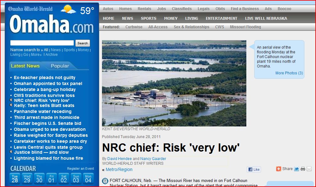
Omaha.com | June 28, 2010 Nuclear Regulatory Commission NRC Chief: Risk 'very low'


Foot traffic restricted by Army Corps near Gavins Point Dam


KDLT Sioux Falls SD | Water Releases Dropping at Garrison Dam in North Dakota


LIVE Web Cam of Gavins Point Dam


Corps: Gavins Point Explosion Rumor ‘Crazy’
Published: Tuesday, June 28, 2011 1:12 AM CDT
The U.S. Army Corps of Engineers official says that a rumor about Gavins Point Dam cracking and being lined with explosives “is crazy.”

A YouTube video surfaced during the weekend from a man making the claim.

“The face of Gavins Point Dam is cracking,” the man says, before explaining that the Corps “or the military” has strung explosives along 25 percent of the structure. The explosives will be detonated this week to relieve pressure on the dam, he claims.

The rumor has circulated widely since the video’s appearance.

“I saw it,” U.S. Army Corps of Engineers Omaha District Commander Col. Bob Ruch said during a conference call Sunday evening. “Whether it’s a joke or a hoax, that’s what the Internet allows. If you want the truth, come to our webpage and sit in on these (conference calls). We’re not stringing explosives on the dam. It’s not cracking. It’s performing as designed.”

Also, Ruch also said during the call that there is a possibility that access to Chief White Crane Recreation Area, located on the east edge of Lake Yankton, could be closed off because of rising waters.

RELATED:

http://www.youtube.com/user/TerralO3


Rising river causes St. Joseph, Missouri casino to close

Flooding closes bridge between Mo., Atchison, Kan.


http://www.kansascity.com/


REAL TIME RADIATION NETWORK

(The following is only a picture of the website - a link)

http://radiationnetwork.com/

ALERT LEVEL = 100 CPM
CPM = Counts Per Minute

From Radiation Network: The numbers represent radiation Counts per Minute, abbreviated CPM, and under normal conditions, quantify the level of background radiation, i.e. environmental radiation from outer space as well as from the earth's crust and air. Depending on your location, your elevation or altitude, and your model of Geiger counter, this background radiation level might average anywhere from 5 to 60 CPM, and while background radiation levels are random, it would be unusual for those levels to exceed 100 CPM. Thus, the "Alert Level" for the National Radiation Map is 100 CPM, so if you see any Monitoring Stations with CPM value above 100, further indicated by an Alert symbol over those stations, it probably means that some radioactive source above and beyond background radiation is responsible.


NOAA Hydrologic - Water Level at Gavins Point Dam, near Ft. Calhoun and Cooper Nuclear Plants


(The following link takes a bit to load all data)
http://water.weather.gov/ahps2/river.php?wfo=oax&wfoid=18705&riverid=203276&view=1%2C1%2C1%2C1%2C1%2C1%2C1%2C1&toggles=10%2C7%2C8%2C2%2C9%2C15%2C6&pt[]=141614&pt[]=144183&pt[]=142396&pt[]=143355&allpoints=143990%2C145585%2C145025%2C145026%2C144876%2C145027%2C143234%2C143184%2C145519%2C145640%2C144217%2C142150%2C142780%2C142853%2C145202%2C141586%2C144582%2C143543%2C144796%2C144098%2C144240%2C141320%2C141614%2C142968%2C144183%2C142574%2C143478%2C142193%2C142760%2C142003%2C142610%2C142396%2C144496%2C147345%2C141899%2C143355%2C142050%2C141570%2C144165%2C143476%2C141703%2C142023%2C144123%2C141863%2C143539%2C143436%2C141917%2C143009%2C142688%2C142640%2C143925%2C143734%2C142729%2C141978%2C143579%2C143348%2C142822&data[]=all&submit=Make+my+River+Page%21#bron1


BLAIR, NEBRASKA NEAR FT. CALHOUN NUCLEAR POWER PLANT


BROWNVILLE, NE - NEAR COOPER NUCLEAR PLANT


RESERVOIR CONTROL CENTER REPORTS

The following is the latest Reservoir Readings on the Upper Missouri River - Sunday June 26, 2011. This report is updated daily. Click on the picture for today's readings in reference to Gavins Point Dam, Ft. Randall Dam in SD, Big Bend Dam in SD, Oahe Dam in SD, Garrison Dam in ND and Fort Peck in Mt.

Link to daily report:
http://www.nwd-mr.usace.army.mil/rcc/reports/showrep.cgi?3MRDTAP7

June 28, 2011


The Cave's Archive: NW DIVISION OF THE US ARMY CORPS OF ENGINEERS RESERVOIR CONTROL CENTER DAILY REPORT


Link: THE CAVE'S OVERFLOW - Archive of the Cave's Daily Flood of 2011 Updates

Monday, June 27, 2011

June 27, 2011 - Corps changes release levels on Missouri River Main Stem Reservoir System #2011MoRivFlood

US Army Corps of Engineers, Omaha District on Monday, June 27, 2011 at 6:20pm

OMAHA, Neb. – The U.S. Army Corps of Engineers is adjusting releases from Fort Peck, Garrison, Oahe and Big Bend this afternoon. The inter-basin reduction in releases follows a rise in Fort Randall reservoir elevations from 1,365 feet June 20 to a record level of 1,372.5 feet June 27.

Fort Peck releases will be reduced from 60,000 cubic feet per second (cfs) to 55,000 cfs; Garrison releases were reduced from 150,000 cfs to 145,000 cfs; Oahe releases will remain at 150,000 cfs for several more days; and Big Bend releases were reduced from 165,000 to 160,000 cfs and will be further reduced to 155,000 cfs tomorrow.

“These changes are part of our normal intrasystem regulation associated with managing reservoir levels, in particular with the high pool levels at Fort Randall,” said Jody Farhat, chief of water management with the U.S. Army Corps of Engineers Northwestern Division.

A three-week forecast of releases from all six reservoirs can be seen here:

“The release changes and dates shown in the forecast should not be assumed to be definitive,” said Farhat. “Depending on inflows, releases could potentially return to peak rates even after being reduced for some period of time.”

These adjustments would reduce Fort Randall inflows and stem the rise of the reservoir elevation. The previous record for Fort Randall was 1,372.2 feet in 1997. This change will not have a significant impact on the Garrison pool level.

During any flood response activities throughout the basin, the Corps will provide regular updates directly to the public via its Facebook (www.facebook.com/OmahaUSACE ) and Twitter accounts (www.twitter.com/OmahaUSACE ). Also, please access our flood response information from our Web site at: http://www.nwo.usace.army.mil/.

View daily and forecast reservoir and river information on the Water Management section of the Northwestern Division homepage at: http://www.nwd-mr.usace.army.mil/rcc.

http://www.facebook.com/notes/us-army-corps-of-engineers-omaha-district/june-27-2011-corps-changes-release-levels-on-missouri-river-main-stem-reservoir-/242387822440587

Omaha.com | Flood test is not over for Ft. Calhoun nuclear plant near Omaha and Cooper Nuclear Plant is planning on operating all summer


COOPER NUCLEAR PLANT NEAR BROWNVILLE, NEBRASKA


Two outside lines of defense against flooding failed Sunday at Fort Calhoun Nuclear Station, shifting the plant to backup electricity for 12 hours.

On Monday, the Omaha Public Power District was studying whether it could patch and refill the temporary water dam that burst. When the dam ruptured, it allowed floodwater to fill in around the plant to a depth of more than two feet, said OPPD spokesman Jeff Hanson.

Sunday's development offers more evidence that the relentlessly rising Missouri River is testing the flood-worthiness of an American nuclear power plant like never before. The now-idle plant, 19 miles north of Omaha, has become an island. And unlike other plants previously affected by high water, Fort Calhoun faces months of flooding.

Also on Monday, the head of the nation's nuclear regulatory agency, his lieutenants and congressional representatives toured the plant.


READ MORE:


http://www.omaha.com/article/20110627/NEWS01/706279901#flood-test-not-over-for-nuke-plant


Magnetosphere Update - June 27, 2011

http://www2.nict.go.jp/y/y223/simulation/realtime/index.html

CAVE NEWS YOU TUBE CHANNEL
DAILY SINCE DECEMBER, 2009


http://www.youtube.com/user/CaveNews?feature=mhum


ALASKA'S HAARP FLUXGATE MAGNETOMETER
http://137.229.36.30/cgi-bin/magnetometer/gak-mag.cgi


EARTHQUAKE UPDATE


Latest Earthquakes Magnitude 2.5 or Greater in the United States and Adjacent Areas and Magnitude 4.5 or Greater in the Rest of the World - Last 7 days


Update time = Tue Jun 28 0:28:48 UTC 2011


MAG UTC DATE-TIME
y/m/d h:m:s
DEPTH
km
Region
MAP 5.5 2011/06/27 23:27:36 50.1 FOX ISLANDS, ALEUTIAN ISLANDS, ALASKA
MAP 4.8 2011/06/27 22:31:33 35.7 OFF THE EAST COAST OF HONSHU, JAPAN
MAP 4.8 2011/06/27 21:13:59 10.4 WESTERN TURKEY
MAP 4.7 2011/06/27 21:05:29 43.3 NEAR THE COAST OF NORTHERN PERU
MAP 5.2 2011/06/27 20:31:47 10.2 BALLENY ISLANDS REGION
MAP 3.4 2011/06/27 19:38:48 3.4 VIRGIN ISLANDS REGION
MAP 5.8 2011/06/27 16:47:14 120.7 FLORES REGION, INDONESIA
MAP 4.5 2011/06/27 16:37:42 15.8 OFF THE EAST COAST OF HONSHU, JAPAN
MAP 4.7 2011/06/27 15:04:49 21.0 NEAR THE EAST COAST OF HONSHU, JAPAN
MAP 2.7 2011/06/27 14:54:54 2.7 SOUTHERN CALIFORNIA
MAP 3.0 2011/06/27 14:31:11 5.2 CENTRAL CALIFORNIA
MAP 5.2 2011/06/27 13:39:10 18.0 SOUTH OF THE KERMADEC ISLANDS
MAP 2.5 2011/06/27 12:52:31 61.2 KENAI PENINSULA, ALASKA
MAP 4.9 2011/06/27 12:12:07 24.7 OFF THE EAST COAST OF HONSHU, JAPAN
MAP 2.9 2011/06/27 10:17:24 94.2 ANDREANOF ISLANDS, ALEUTIAN IS., ALASKA
MAP 4.0 2011/06/27 09:28:53 42.9 ANDREANOF ISLANDS, ALEUTIAN IS., ALASKA
MAP 5.0 2011/06/27 04:57:11 18.3 NEAR THE NORTH COAST OF PAPUA, INDONESIA
MAP 4.5 2011/06/27 04:39:16 33.7 NEAR THE NORTH COAST OF PAPUA, INDONESIA
MAP 4.8 2011/06/27 04:16:51 164.8 SOUTH OF THE FIJI ISLANDS
MAP 2.9 2011/06/27 03:39:00 48.4 ANDREANOF ISLANDS, ALEUTIAN IS., ALASKA
MAP 4.5 2011/06/27 00:56:39 162.5 POTOSI, BOLIVIA
MAP 5.6 2011/06/27 00:30:31 43.1 TONGA
MAP 2.5 2011/06/27 00:07:21 15.9 MONA PASSAGE, PUERTO RICO


https://blogger.googleusercontent.com/img/b/R29vZ2xl/AVvXsEi-STGU330TIVW_lYfEGVaZIOfl2Na0qlEGn8Kqx-Uhvv437BBpJNtPpWKMRrfrSuG8OnsFf1ukWDFFwO2klAnJOZNXUCwa00psu8h9dL5oOcQYgTAy5o1Lr3OF1Vt3lCVCKPI2pBbVpT89/s1600/Capture.JPG
New Madrid Center for Earthquake Research and Information


RECENT CENTRAL STATES EARTHQUAKES

map 2.0  2011/06/26     2 km ( 2 mi) E   of Greenbrier, AR 
map 1.6 2011/06/25 6 km ( 4 mi) ESE of Caraway, AR
map 2.4 2011/06/25 8 km ( 5 mi) NNW of Maypearl, TX


SOLAR UPDATE


QUIET SUN: Solar activity is very low. Only one small sunspot group (AR1241) is crossing the visible face of the sun, and it poses no threat for strong flares.


Solar Update: The sun consists currently of two sunspot regions 1240 and 1241. Both are struggling to remain visible and solar activity should remain at very low levels in the short term.


MOON UPDATE

Sioux City Journal | Corps doesn't expect to use SD Oahe Dam's spillway gates (which is an earthen channel instead of concrete and subject to erosion)


PIERRE, S.D. (AP) Monday, June 27, 211 8:16 am — The Corps of Engineers says that despite heavy weekend rains in parts of the Missouri River basin it expects the Oahe Dam reservoir in South Dakota to peak just a few inches below the top of the emergency spillway gates.

That means the agency wouldn't have to use the spillway, which is an earthen channel instead of concrete and subject to erosion. Jody Farhat with the corps tells South Dakota Public Radio that officials are trying to avoid using the spillway. The reservoir level is less than half a foot from the top of the gates because of heavy spring snowmelt and rains.

KCCR radio reports that the corps plans to increase Oahe releases to 160,000 cubic feet per second by Friday, then begin dropping them back the following Tuesday.


RELATED


Uploaded by on Jun 26, 2011

160,000 Cubic Feet Per Second flowing through the six diversion tubes below the Oahe Dam in Pierre, SD. This is the largest discharge of water in the history of the world's largest earthen dam.

Joyce Riley's Power Hour News | Monday June 27, 2011

Flood wall fails at Fort Calhoun
Omaha World Herald - June 26, 2011 Floodwaters surrounded several buildings at the Fort Calhoun Nuclear Station early Sunday morning after a water-filled wall collapsed. The 2,000-foot berm collapsed about 1:25 a.m. Sunday due to “onsite activities,” OPPD officials said. The Aqua Dam provided supplemental flood protection and was not required under NRC regulations.

Flood berm collapses at Nebraska nuclear plant
Associated Press June 26, 2011 The berm's collapse didn't affect the reactor shutdown cooling or the spent fuel pool cooling, but the power supply was cut after water surrounded the main electrical transformers, the NRC said. Emergency generators powered the plant until an off-site power supply was connected Sunday afternoon, according to OPPD.

Flood berm collapsed after being punctured by an unidentified piece of machinery: OPPD
(CNN) -- A water-filled berm protecting a nuclear power plant in Nebraska from rising floodwaters collapsed Sunday, according to a spokesman, who said the plant remains secure. Some sort of machinery came in contact with the berm, puncturing it and causing the berm to deflate, said Mike Jones, a spokesman for the Omaha Public Power District (OPPD), which owns the Fort Calhoun plant.

Flooding: The worst is yet to come
Omaha World Herald - June 26, 2011 Imagine roughly 55 million acres — the entire surface of Nebraska and southwest Iowa — covered in a foot of water. Now imagine trying to funnel all that water down a drainage canal surrounded by airports and homes, businesses and farms. You can begin to grasp the unprecedented, slow-developing danger facing folks from Montana to Missouri from the Great Flood of 2011.

NRC Chairman Tours Flood-Threatened Nuke Plant
KETV7 Omaha - June 26, 2011 Plant officials said the encapsulated spent fuel rods at the plant, which continues to operate, can withstand being submerged in 50 feet of water for an extended period of time.

Midwest Floods: Waters Breach Berm at Fort Calhoun Nuclear Station in Nebraska
ABC: Nevertheless, federal inspectors are on the scene, and the federal government is so concerned the head of the Nuclear Regulatory Commission is headed to the plant. There was no protecting thousands of homes in Minot, N.D., where massive flooding of the Souris River hit its peak today, flooding more than 4,000 homes, including Leslie Dull's. Article includes a video report.

Concern at Nebraska Reactors as Floodwaters Rise
NYT - BROWNVILLE, Neb.June 26, 2011 — Like inhabitants of a city preparing for a siege, operators of the nuclear reactor here have spent days working to defend it against the swollen Missouri River at its doorstep. On Sunday, eight days after the river rose high enough to require the operators to declare a low-level emergency, a swarm of plant officials got to show off their preparations to the chairman of the Nuclear Regulatory Commission.

New Madrid's Giant Pipeline Bomb
"Virtually every natural gas pipeline in the nation is built over that fault," Geller says. "You'll see the explosion reflected off the moon."

The Purposeful Flooding of America's Heartland
Conspiracy Cafe - The Missouri River basin encompasses a vast region in the central and west-central portion of our country. This river, our nation's longest, collects the melt from Rocky Mountain snowpack and the runoff from our continents' upper plains before joining the Mississippi river above St. Louis some 2,300...

FLOOD ALERT FORT CALHOUN
Conspiracy Cafe - New photos and map of the Missouri Dams and Fort Calhoun / Cooper Nuclear Power Plants.

Soros buying up flood-ravaged farm land; Obama’s executive order establishes ‘Rural Council’
Who’s buying up flood ravaged farm land. Related Video

Thom Hartmann: Nuclear Power - "We Almost Lost Nebraska"
Tue Jun 21 RT TV - A recap of the Nuclear problems here in the U.S.

United Nations Nuclear Bank
The media hailed Warren Buffett last December for donating $50 million dollars toward a United Nations nuclear bank with control over uranium enrichment. The intent is control over nuclear weapons and nuclear power by the elites who are the true forces behind the UN.

EPA and Corps plan to seize control of all water
A full scale attack by EPA and the Army Corps of Engineers to take control of all water from any source whatsoever is under way.

American in Tripoli: First Hand Account
RTAmerica - Investigative reporter Wayne Madsen, who spent some time in Libya, shares his views on what's really going on in the country and why the mainstream media deliberately misinforms the public about real goals of NATO. When asked where the media is on this, his reply was, "The media is silent and worse as I pointed out, they're putting out disinformation rather than reporting the facts as they are seeing them on the ground."

Ron Paul Slams Absurd Libya War Powers Debate
Rep. Ron Paul (R-Tex.), a candidate for the Republican presidential nomination, came down hard today against a House bill (HR 2278) that would have limited the use of funds for the U.S.’s involvement in the Libya War. The House also rejected the limited funding bill for the Libya War, while also striking down a resolution that would have authorized the limited use of U.S. Armed Forces in Libya.

Enter the dragon 'to save the euro

It is in the interest of cash-rich China to help resolve the eurozone debt crisis, but Chinese premier Wen Jiabao, who is visiting Britain and Continental Europe, will want a share of the West’s buying power in return .

Time magazine cover features shredded U.S. Constitution, asks if it still matters
Provocative? Perhaps, but that’s nothing new for Time magazine with a history of taking iconic American symbols and using them to make political statements.

FBI Arrests Dangerous Gangster Without Kicking His Door Down
Over the last few decades, SWAT teams and paramilitary-style police tactics have proliferated like a wild fire. According to a recent USA Today interview with Peter Kraska, a criminologist whose work focuses on police militarization, SWAT teams were deployed only about 2,000 to 3,000 times per year in the early to mid 80′s. That number has shot up to about 70,000 and 80,000 per year in the present.

White House loosens border rules for 2012
President Barack Obama’s administration is quietly offering a quasi-amnesty for hundreds of thousands of illegal immigrants, while aiming to win reelection by mobilizing a wave of new Hispanic voters, say supporters of stronger immigration law enforcement. Related video.

Bolivia Set To Withdraw From U.N. Treaty Banning Drugs
The South American nation of Bolivia is set to withdraw from the United Nations Single Convention on Narcotic Drugs, adopted in 1961 to outlaw "illicit substances" across the planet. It plans the move in protest of the U.N.'s classification of coca leaves as an illegal drug.

Economy Expected to Have Major Slide in Months Ahead
A drumbeat of disappointing data about consumer behavior, factory sales and weak hiring in recent weeks has prompted economists to ratchet down their 2011 economic forecasts to as little as half what they expected at the beginning of the year.

It Gets Even Crazier: AT&T, Comcast, And Other ISPs Introduce The “Three Strikes” Internet Censorship Deal
Completely over the top, even compared to everything else we’re up against: Entertainment industry sources are leaking that they’ve convinced Internet service providers to start restricting people’s web access. If you’re accused of downloading or streaming three files they’ll consider messing with your Internet connection — and maybe even decide what sites you’re allowed to visit.

Adoption of Genetically Engineered Crops in the U.S.
U.S. farmers have adopted genetically engineered (GE) crops widely since their introduction in 1996, notwithstanding uncertainty about consumer acceptance and economic and environmental impacts.

Anti-foaming agent found in Chicken McNuggets
(NaturalNews) Ever wonder what's really found in Chicken McNuggets? Some of the ingredients, it turns out, seem to belong more to an industrial factory of some kind, not a food retailer. According to the McDonald's Corporation...

FDA officially declares the sun unsafe, urges public to lather toxic sunscreen on skin
(NaturalNews) The absurdity of many US government recommendations would be humorous if not for the millions of Americans that take them seriously. The latest pseudo-scientific nonsense being peddled by Big Brother is the...

Beware -- Some 'Green' Cleaners are Deceptive and Toxic
The manufacturers of the "Green" cleaning product Simple Green's claim that it is non-toxic, biodegradable, non-hazardous, non-flammable, and non-corrosive. But the Material Data Safety Sheet for Simple Green reveals that the formula contains 2-Butoxyethanol -- a petrochemical solvent.

Rush Medical Center scientists study cinnamon for fighting MS.
Cinnamon may be a non-toxic way to stop myelin sheath destruction from multiple sclerosis, suggested by animal studies. Now researchers plan to move forward with research on the impact of cinnamon that might halt nerve fiber damage that occurs from MS that is an autoimmune disease. es do.

Seepage Blankets To Go Up In Council Bluffs
COUNCIL BLUFFS, Iowa -- Council Bluffs officials are preparing to use another tool in the fight against the rising Missouri River. Starting Friday, the Army Corps of Engineers will prepare to install seepage blankets along sections of the river levee.

Levee Failure Prompts More Evacuations

BROWNVILLE, Neb. -- More mandatory evacuations have been ordered after another levee breach in Atchison County, Mo. About 250 homes have been cleared in Phelps City, Langdon and Watson.

A Nuclear Plant's Flood Defenses Trigger a Yearlong Regulatory Confrontation
NRC yet to complete its evaluation of flood defenses installed at Fort Calhoun nuclear plant — Other flooding matter “still under investigation”

Food Drives Show Continued Support for Joplin
St. Louis (KMOX) – It’s been a little more than a month since a deadly tornado ravaged the town of Joplin. It left deep, lingering scars destroying thousands of buildings and taking more than 150 lives. But all over the country, and in the city of St. Louis, people have turned out to heal those wounds.

Robot, drone fail on Japan nuke-plant missions
TOKYO—Two high-tech machines intended to help workers at Japan's tsunami-hit nuclear plant malfunctioned Friday, including a long-awaited Japanese robot making its first attempt to take important measurements in areas too dangerous for humans.

Doctor says radiation test on cars ‘scientifically negligent’
Australia’s nuclear safety regulator decided there is no need to screen any more sea or air cargo arriving from Japan — Dock workers concerned about radiation exposure

Sunflowers to clean radioactive soil in Japan
Campaigners in Japan are asking people to grow sunflowers, said to help decontaminate radioactive soil, in response to the Fukushima nuclear disaster that followed March's massive quake and tsunami. Volunteers are being asked to grow sunflowers this year, then send the seeds to the stricken area where they will be planted next year to help get rid of radioactive contaminants in the plant's fallout zone.

Exclusive: Top U.S. admiral admits we are trying to kill Qaddafi
The top U.S. admiral involved in the Libya war admitted to a U.S. congressman that NATO forces are trying to kill Libyan leader Muammar al-Qaddafi. The same admiral also said he anticipated the need for ground troops in Libya after Qaddafi falls, according to the lawmaker.

Mexican troops cross into the United States at Bridge Two
A convoy of three military trucks loaded with Mexican soldiers crosses the border at Bridge Number Two clearly violating international law.

Obama Administration Caught Running False Flag Against Second Amendment
Despite the Obama administration’s best efforts to characterize Operation Fast and Furious, a recently revealed ATF program that sought to put U.S.-based firearms into the hands of Mexican drug smugglers, as little more than a ‘screw up’, the most damning evidence strongly indicates that the whole operation was in fact an attempt to launch a false flag assault on the second amendment rights of the American people.

NASA To Fly Low Over Region For Air Quality Study
WASHINGTON (WJZ)—Don’t panic if you see large planes flying unusually low over Maryland roadways next week. It’s all part of a major plan by NASA to help study air pollution over major cities.

Obama to step into debt talks next week
Obama's intervention follows a Republican walkout from crucial talks on the issue and warnings by top party leaders that they will not accept White House demands to close tax loopholes and hike rates on the wealthiest Americans.

House rejects measure to continue US role in Libya
WASHINGTON – The House refused to vote President Barack Obama the authority for U.S. military operations against Libya on Friday but stopped short of cutting off funds for the mission, a mixed message reminiscent of congressional unease on Vietnam and more recent wars.

Commander In Chief Misspeaks About Soldier Killed in Afghanistan
During his remarks to troops at Fort Drum today, the President was reminiscing about the times he has spent with the US Army's 10th Mountain Division, when he got something wrong
.

US concerned by planned aid flotilla for Gaza
The flotilla is due to mark the anniversary last month of an Israeli commando raid that killed nine Turkish activists aboard a ship that was part of a flotilla trying to break the Israeli-imposed blockade of Gaza.

Concerns Continue to Mount on U.S. Bioweapons Violations
The Center for Disease Control has declined to confirm or deny allegations that the United States government is stockpiling biological and/or chemical weapons at Sierra Army Depot, a military base in Northern California.

Al Gore, Agenda 21 And Population Control
Imagine going to sleep one night and waking up many years later in a totally different world. In this futuristic world, literally everything you do is tightly monitored and controlled by control freak bureaucrats in the name of "sustainable development"...

TSA claims it will soon stop molesting little children, but not adults, veterans or senior citizens
In a policy change announcement, the TSA now claims it will soon stop molesting little children by reaching into their pants and feeling their genitals. That we live in such a police state today where the opening...

US venture capitalists oppose 'rogue website' bill
WASHINGTON (AFP) - A group of top US venture capitalists has written a letter to the US Congress opposing a bill aimed at cracking down on websites selling pirated and counterfeit goods.

Newly published research in leading journals AGAINST fluoride and vaccines
"The prolonged ingestion of fluoride may cause significant damage to health and particularly to the nervous system," concludes a review of studies by researchers Valdez-Jimenez, et al. published in Neurologia (June 2011), reports New York State Coalition Opposed to Fluoridation, Inc. (NYSCOF).

Psychiatrists with corrupt pasts found working in juvenile justice facilities and doping children
An investigation into the massive drugging of kids in Florida juvenile jails has uncovered psychiatric doctors with deplorable records working for the state's Department of Juvenile Justice (DJJ). Their histories...

Monsanto's Leading Soldier in the War on Raw Milk
In recent months there have been many articles dealing with the intensification of the war on milk launched by the FDA. (See here and here. Also here.) I myself, have written articles explaining the dangers of corporate control of the dairy industry and the specific health concerns related to the use of antibiotics and rBGH in the production of milk.

Peru implements ten-year ban on GMOs
A rarity in the world today, the South American nation of Peru has yet to be contaminated by the import, cultivation, or breeding of any genetically-modified (GM) crops -- at least not openly -- unlike some...

Genetically modified organisms inject DNA into intestinal bacteria

Food that contains genetically engineered organisms can transfer genetic material into the DNA of bacteria in the intestinal tract leading to a myriad of health consequences. Responsible scientists have been warning about the potential dangers of releasing genetically modified organisms into the food supply for years.

Census shows whites lose US majority among babies
For the first time, more than half of the children under age 2 in the U.S. are minorities, part of a sweeping race change and a growing age divide between mostly white, older Americans and fast-growing younger ethnic populations that could reshape government policies.

Study Confirms Safety, Cancer-targeting Ability Of Nutrient In Broccoli
Sulforaphane, one of the primary phytochemicals in broccoli and other cruciferous vegetables that helps them prevent cancer, has been shown for the first time to selectively target and kill cancer cells while leaving normal prostate cells healthy and unaffected.

Deep History of Coconuts Decoded: Origins of Cultivation, Ancient Trade Routes, and Colonization of the Americas
DNA analysis of more than 1,300 coconuts from around the world reveals that the coconut was brought under cultivation in two separate locations, one in the Pacific basin and the other...

Pine bark, CoQ10 together improve physical fitness and heart health
A new study conducted by researchers from Chieti-Pescara University in Italy has revealed that taking pine bark extract in conjunction with Coenzyme Q10 helps improve heart health in heart failure patients by...

California fair vendor tests limits of Americans' junk food threshold by serving deep-fried Kool-Aid
There appears to be no limit to what some Americans are willing to put in their bodies, even in the so-called health mecca of California. According to a recent FOX News report, a vendor at the San Diego County...


http://www.thepowerhour.com/news.htm
The Power Hour: Show-Schedule (7-10am CST) ···Listen Live
The Power Hour Archives http://www.gcnlive.com/programs/powerHour/