DAILY SINCE DECEMBER, 2009
http://www.youtube.com/user/CaveNews?feature=mhum


Latest Earthquakes Magnitude 2.5 or Greater in the United States and Adjacent Areas and Magnitude 4.5 or Greater in the Rest of the World - Last
Update time = Thu Aug 4 0:35:11 UTC 2011
| MAG | UTC DATE-TIME y/m/d h:m:s | DEPTH km | Region | |
|---|---|---|---|---|
| MAP | 5.8 | 2011/08/04 00:16:08 | 37.8 | SOUTHERN SUMATRA, INDONESIA |
| MAG | UTC DATE-TIME y/m/d h:m:s | DEPTH km | Region | |
|---|---|---|---|---|
| MAP | 5.2 | 2011/08/03 22:52:16 | 26.8 | MOLUCCA SEA |
| MAP | 5.2 | 2011/08/03 22:48:12 | 23.9 | NEW BRITAIN REGION, PAPUA NEW GUINEA |
| MAP | 5.9 | 2011/08/03 22:39:23 | 8.2 | NEW BRITAIN REGION, PAPUA NEW GUINEA |
| MAP | 3.9 | 2011/08/03 22:31:57 | 9.6 | SOUTHERN YUKON TERRITORY, CANADA |
| MAP | 4.7 | 2011/08/03 21:44:10 | 500.1 | FIJI REGION |
| MAP | 4.3 | 2011/08/03 21:41:19 | 307.4 | MARIANA ISLANDS REGION |
| MAP | 4.3 | 2011/08/03 21:33:56 | 164.8 | NORTHERN COLOMBIA |
| MAP | 5.1 | 2011/08/03 20:39:40 | 191.7 | VANUATU |
| MAP | 3.1 | 2011/08/03 20:29:15 | 18.3 | ANDREANOF ISLANDS, ALEUTIAN IS., ALASKA |
| MAP | 3.1 | 2011/08/03 20:27:01 | 25.4 | VIRGIN ISLANDS REGION |
| MAP | 5.2 | 2011/08/03 20:02:19 | 80.1 | NORTHERN SUMATRA, INDONESIA |
| MAP | 2.9 | 2011/08/03 19:26:49 | 64.3 | VIRGIN ISLANDS REGION |
| MAP | 5.0 | 2011/08/03 19:23:15 | 52.3 | KERMADEC ISLANDS REGION |
| MAP | 4.5 | 2011/08/03 16:32:28 | 4.8 | NEAR THE EAST COAST OF HONSHU, JAPAN |
| MAP | 2.7 | 2011/08/03 15:39:52 | 10.0 | BAJA CALIFORNIA, MEXICO |
| MAP | 3.2 | 2011/08/03 14:46:00 | 6.0 | PUERTO RICO REGION |
| MAP | 5.2 | 2011/08/03 14:35:00 | 11.6 | KEPULAUAN MENTAWAI REGION, INDONESIA |
| MAP | 4.4 | 2011/08/03 14:23:25 | 182.9 | SALTA, ARGENTINA |
| MAP | 2.7 | 2011/08/03 14:19:31 | 39.7 | ISLAND OF HAWAII, HAWAII |
| MAP | 2.5 | 2011/08/03 14:05:23 | 49.3 | ANDREANOF ISLANDS, ALEUTIAN IS., ALASKA |
| MAP | 4.2 | 2011/08/03 13:32:50 | 35.0 | MOLUCCA SEA |
| MAP | 3.2 | 2011/08/03 12:43:37 | 55.2 | RAT ISLANDS, ALEUTIAN ISLANDS, ALASKA |
| MAP | 2.7 | 2011/08/03 11:17:15 | 6.0 | PUERTO RICO REGION |
| MAP | 2.7 | 2011/08/03 11:08:37 | 6.0 | PUERTO RICO REGION |
| MAP | 2.5 | 2011/08/03 10:19:30 | 2.2 | NORTHERN CALIFORNIA |
| MAP | 3.1 | 2011/08/03 08:19:09 | 115.5 | RAT ISLANDS, ALEUTIAN ISLANDS, ALASKA |
| MAP | 3.4 | 2011/08/03 08:10:36 | 8.8 | ANDREANOF ISLANDS, ALEUTIAN IS., ALASKA |
| MAP | 2.9 | 2011/08/03 06:49:11 | 111.6 | MONA PASSAGE, PUERTO RICO |
| MAP | 4.9 | 2011/08/03 06:11:34 | 129.4 | KEPULAUAN SANGIHE, INDONESIA |
| MAP | 4.7 | 2011/08/03 06:10:47 | 62.6 | FOX ISLANDS, ALEUTIAN ISLANDS, ALASKA |
| MAP | 4.2 | 2011/08/03 06:08:37 | 3.6 | CENTRAL ALASKA |
| MAP | 3.3 | 2011/08/03 05:54:16 | 122.0 | SOUTHERN ALASKA |
| MAP | 5.0 | 2011/08/03 04:51:42 | 597.5 | FIJI REGION |
| MAP | 3.1 | 2011/08/03 04:48:36 | 90.1 | ISLA SAONA, DOMINICAN REPUBLIC |
| MAP | 2.6 | 2011/08/03 03:32:58 | 42.3 | KENAI PENINSULA, ALASKA |
| MAP | 5.1 | 2011/08/03 03:20:21 | 19.1 | FIJI REGION |
| MAP | 3.1 | 2011/08/03 02:58:40 | 31.3 | PUERTO RICO REGION |
| MAP | 3.3 | 2011/08/03 01:45:50 | 11.2 | PUERTO RICO REGION |
| MAP | 4.3 | 2011/08/03 01:36:12 | 2.0 | FRANCE |
| MAP | 2.7 | 2011/08/03 00:43:33 | 9.1 | NORTHERN CALIFORNIA |
| MAP | 2.6 | 2011/08/03 00:13:53 | 0.0 | NORTHERN CALIFORNIA |
Yellowstone Seismogram Reporting Link:

PACIFIC NORTHWEST SEISMIC NETWORK
RECENT CENTRAL STATES EARTHQUAKES
http://folkworm.ceri.memphis.edu/recenteqs/Quakes/quakes0.htm
1.9 11 km ( 7 mi) NNW of Fairfield Glade, TN
1.5 9 km ( 6 mi) N of Fairfield Glade, TN
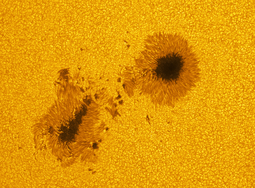
SOLAR UPDATE

M6-CLASS SOLAR FLARE: Sunspot 1261 unleashed another strong solar flare this morning--an M6-class flash at 1348 UT. Like yesterday's eruption from the same active region, this explosion propelled a CME in the general direction of Earth. ETA: August 5th. Stay tuned for additional analysis.
A listening station above the Arctic Circle in Norway reports ionospheric waves and VHF radio noise associated with today's M6-flare: their data.
INCOMING CLOUD: Yesterday's M1-class eruption from sunspot 1261 was observed by three spacecraft: SOHO, STEREO-A and STEREO-B. Using data from those three points of view, analysts at the GSFC Space Weather Lab have made a 3-dimensional model of the CME now en route to Earth

M6.0 Solar Flare and CME: A Moderate Solar Flare reaching M6.0 took place around Sunspot 1261 at 13:47 UTC Wednesday and was fairly long in duration. A brief R2 Radio Blackout resulted. A Coronal Mass Ejection (CME) was associated with this event and can be seen in the movie I created below. When viewing the CME in the latest Lasco C2 movie it appears that a majority of the cloud is expanding away from earth. A portion of it however may still sweep past us around August 7th and stir up minor geomagnetic storming at high latitudes.1261 and 1263 produce pair of M-Class Flares: An M1.1 Solar Flare took place around Sunspot 1261 at 03:37 UTC Wednesday morning followed an hour later by a M1.7 flare around Sunspot 1263 at 04:32 UTC.
Solar Update / Aurora Watch: Sunspots 1261 and 1263 will continue to be a threat for strong solar flares over the next 24 hours. There is also a very slim chance for an X-Class event.
MOON UPDATE
