AMTRAK SUSPENDS MISSOURI TRAINS BECAUSE OF FLOODING

http://www.kansascity.com/2011/07/09/3003547/amtrak-suspends-missouri-trains.html


Pierre, South Dakota
Saturday July 8, 2011
Corps says public 'welcome to scrutinize' its data, release levels hold steady at Oahe and Big Bend
http://capjournal.com/articles/2011/07/08/breaking_news/doc4e178ce66565a929447550.txt

 Published Saturday July 9, 2011f
Reservoirs gain a little room
Record set: July 2, 2011, 72.8 million acre feet.
Previous record: 72.1 million acre feet, 1975.
There's a glimmer of good news in the flood-stricken Missouri River basin.
The amount of water being held back by the six massive upstream dams peaked July 2 and has begun dropping slightly.
Barring heavy rains, that trend will continue, said Jody Farhat of the Army Corps of Engineers.
“We're gaining empty space and we're losing water, so that's a good thing,” said Farhat, who regulates the dams as chief of the corps' water management office in Omaha.
“We've barely just turned this corner. We're not far enough down the road to say we're out of the woods by any means. But certainly it's movement in the right direction.”
Friday was the sixth consecutive day in which more water was being released from the system than was coming in, she said.
A rainy week is in the forecast, however, so it remains possible that conditions could reverse.
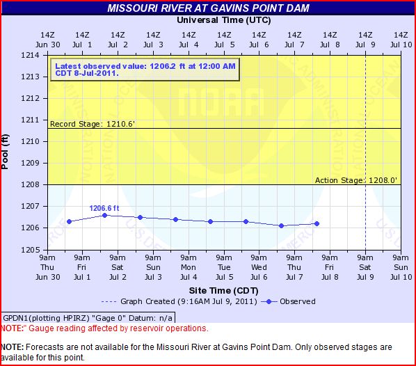
“Gaining extra space” is crucial to avoiding releases from Gavins Point Dam greater than the current extraordinary level of 160,000 cubic feet of water per second.
Gavins Point affects Missouri River levels from the Nebraska-Iowa border southward. High flows out of Gavins Point have collapsed levees, inundated homes, businesses and highways, and threatened the Fort Calhoun Nuclear Station and the Omaha area, including the city's airport and sewage treatment system.
The possibility that conditions could worsen remains a genuine threat until river levels below Gavins Point drop substantially. No one yet knows when that will be.
“We're still in a very active flood fight in the Council Bluffs and Omaha area and south,” Col. Robert Ruch, commander of the corps' Omaha District, said Friday afternoon.
National Guard troops and others are continuously monitoring the region's levees, and emergency repairs are being done to keep them from deteriorating, said Lt. Gov. Rick Sheehy, Nebraska's director of Homeland Security.
Because levees are holding back water for longer than they were designed, conditions could continue to deteriorate, he said.
“Until the water levels really begin to drop in the Missouri River itself, we'll continue to be at a critical state,” Sheehy said. “People shouldn't become complacent. They should still listen to officials.”
Record amounts of water remain stored behind the dams. That water must drain out, which means for the foreseeable future dangerously high levels of Missouri River water will continue to press on the region's levees.
The total amount of water being held back by the dams, which constitute one of the nation's largest reservoir systems, has been at record levels since June 21. It remains so today.
As of July 2, there was 1.5 percent room for flood storage in the reservoirs. By Friday, that had improved to 3.1 percent.
Rain is the wild card.
In late June, so much rain fell in South Dakota — 3 to 5 inches — that the corps is having to curtail releases in the upstream dams to give the lower dams more time to flush out that runoff.
In a year of many records on the Missouri River, June established another stunner: the most runoff in a single month since record-keeping began in 1898 — greater even than during the epic flood of April 1952.
The runoff was about half snowmelt and half rain, Farhat said.
The good news is that most of the snows have melted.
At the start of June, 75 percent to 95 percent of the snow remained in the upper basin. Now less than 8 percent remains.
Farhat said it will be the end of July before the corps has enough room to spare in the reservoirs — 2 to 3 feet — to give it a little flexibility if heavy rains fall.
“We'll feel much more comfortable than we do today. We're just barely below the crest,” she said.
Within a week or two, Farhat said, the corps expects to release a forecast for when Nebraska and Iowa will see decreased releases from Gavins Point Dam. Sometime in August, she said, those releases should begin dropping.
For now, though, so much water is flowing through the system that the amount coming into Gavins Point would be enough to completely fill the reservoir in 1½ days were it empty, she said.
As much heartache as this flooding is causing, Ruch said, “It would have been much worse if we hadn't had this system in place.”
http://www.omaha.com/article/20110709/NEWS01/707099894#reservoirs-gain-a-little-room
Iowa Gov Branstad suggested establishing a Missouri River Coalition of Downstream States that would include Iowa, Nebraska, Missouri and Kansas.

More flood stories from the Sioux City Journal
- OTHER VOICES: Spirit of compromise must rise from floodwaters
- USDA issues disaster declaration for 6 Iowa counties
- Three illegal workers arrested in Dunes' restricted area
- Nearly 500 Nebraska homes damaged by flooding
- Ag disaster declaration OK'd for 6 Iowa counties, including Woodbury
- Ag secretary questions Corps on Missouri flooding
- Senators seek hearing on Missouri management
- Mold cleanup training offered in North Sioux City
- Mo. agency urges insurers to extend flood coverage
- OTHER VOICES: Flooding must reignite river discussion
- Iowa DOT to raise portion of I-29 near Blencoe
- More land washes away at Decatur Bridge
- Union, Dakota counties report levees holding steady
Read more:
http://www.siouxcityjournal.com/special-section/2011_flood/
RadiationNetwork.com

NOAA Hydrologic - Water Level at Gavins Point Dam, near Ft. Calhoun and Cooper Nuclear Plants

(The following link takes a bit to load all data)
http://water.weather.gov/ahps2/river.php?wfo=oax&wfoid=18705&riverid=203276&view=1%2C1%2C1%2C1%2C1%2C1%2C1%2C1&toggles=10%2C7%2C8%2C2%2C9%2C15%2C6&pt[]=141614&pt[]=144183&pt[]=142396&pt[]=143355&allpoints=143990%2C145585%2C145025%2C145026%2C144876%2C145027%2C143234%2C143184%2C145519%2C145640%2C144217%2C142150%2C142780%2C142853%2C145202%2C141586%2C144582%2C143543%2C144796%2C144098%2C144240%2C141320%2C141614%2C142968%2C144183%2C142574%2C143478%2C142193%2C142760%2C142003%2C142610%2C142396%2C144496%2C147345%2C141899%2C143355%2C142050%2C141570%2C144165%2C143476%2C141703%2C142023%2C144123%2C141863%2C143539%2C143436%2C141917%2C143009%2C142688%2C142640%2C143925%2C143734%2C142729%2C141978%2C143579%2C143348%2C142822&data[]=all&submit=Make+my+River+Page%21#bron1
BLAIR, NEBRASKA NEAR FT. CALHOUN NUCLEAR POWER PLANT

BROWNVILLE, NE - NEAR COOPER NUCLEAR PLANT

RESERVOIR CONTROL CENTER REPORTS
Link to daily report:
The Cave's Archive: NW DIVISION OF THE US ARMY CORPS OF ENGINEERS RESERVOIR CONTROL CENTER DAILY REPORT


Link: THE CAVE'S OVERFLOW - Archive of the Cave's Daily Flood of 2011 Updates