North Dakota's US Senators say they want an immediate investigation of how so much water was allowed to flow through the Souris-Mouse River complex in the US and Canada
Jul 4 2011 8:58PM
The river set records at every location along its path through north-central North Dakota - most often three or four feet over previous high levels.
In addition, they are part of a working group involving senators from all states along the Missouri River - a river that is also experiencing major flooding this year.
Senator John Hoven says there are answers that need to come from the US Army Corps of Engineers, which regulates the Missouri and Mouse Rivers in flood situations.
(Sen. John Hoeven, -R- ND) "We're going to want to know from the Corps, what happened, why did it happen, and how can we prevent it from happening again in the future. That what Senator Conrad and I are going to ask because we have to take steps to prepare for next year." Senator Kent Conrad says Corps officials point to unprecedented snowmelt and rain storms as causes of the Mouse River flooding. But he says it's important to revise working orders to deal with unexpected problems.
(Sen. Kent Conrad, -D- ND) "The management of the reservoirs is based on previous data, how high did the river get in previous years. That's all changed because there is going to have to be a re-doing of the manual that guides how these reservoirs are run because the facts have changed and changed dramatically."
The senators say they'll be pressing the Corps of Engineers for a quick start to the investigation to assure flood protections of some sort are in place before next spring.
But those protections would not be any permanent fixes - those projects are likely to take years to come
http://www.kxnet.com/custom404.asp?404;http://www.kxnet.com/t/corps-of-engineers/800603.asp
RELATED:
Western Flood Control Sites – North Dakota: Lake Ashtabula, Homme Lake, Souris River
http://www.mvp.usace.army.mil/recreation/default.asp?pageid=1468
HEAVY RAINS CAUSING ADDITIONAL FLOODING HITS AREA LOCATED BETWEEN THE MISSOURI BASIN DAMS OF OAHE AND BIG BEND DAMS IN SOUTH DAKOTA


http://siouxcityjournal.com/news/state-and-regional/south-dakota/article_c0b8a2a0-a705-11e0-908b-001cc4c002e0.html
Sioux City Journal | FLOODING MISSOURI RIVER IS THREAT TO BACKED UP TRIBUTARIES - WATER TRAFFIC JAMS

Tuesday July 5, 2011
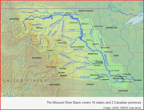
LINCOLN, Neb. - In a season of flooding by some of the nation's biggest rivers, it's streams most Americans have never heard of that could cause some of the worst problems in the Midwest.
Hundreds of tributaries that feed the congested Missouri River face a greater-than-normal flood risk this summer because of water levels that have kept them from draining. The Missouri is expected to remain near historic highs for months, which means the threat will remain through summer- a season when the Midwest often is beset with thunderstorms that can quickly dump heavy rain.
University of Iowa engineering professor Witold Krajewski, director of the Iowa Flood Center, compared the situation to a "traffic jam" of water. It started with the sustained release of massive amounts of water from dams on the upper Missouri, caused by spring rain and a heavy Rocky Mountain snowpack that filled reservoirs.
"It's like a football game and baseball game getting out at the same time," Krajewski said. "There are all these cars trying to move. It doesn't take long before drivers can't get out of the side streets."
Backed-up tributaries in South Dakota and Missouri have already submerged streets and threatened homes near the point where they reach the surging river. In Hamburg, Iowa, work crews are keeping close watch on changing levels of the Nishnabotna River to their east, as they try to hold off the Missouri River from the west.
Some tributaries, such as the Nodaway and Big Sioux, are so backed up with high water in the larger river that local officials worry that a well-placed downpour could suddenly pose a new flooding threat.
Nebraska State Climatologist Al Dutcher said the problem won't end soon.
"We're probably going to see the tributaries be problematic all year," Dutcher said. "If we get a monster storm that drops 3 to 4 inches of rain into a basin, all that water has to be evacuated. As it goes out toward the Missouri River, it's going to back up."
Bob Anderson, a spokesman for the Army Corps of Engineer in Vicksburg, Miss., said similar problems could have happened during spring flooding along the Mississippi River, but heavy rainstorms didn't occur at key times and tributaries didn't swell beyond their normal size.
The flooding along the Souris River that has devastated Minot, N.D. is due to heavy rains, not a tributary backup.
In southwest Iowa, crews in Hamburg have devoted most of their time to building a temporary levee to stop the Missouri, but officials said there is little they can do to protect against flooding by the Nishnabotna if an ... read more ............
Bluffs Officials: Sump Pumps Hurting, Not Helping
KETV OMAHA, Neb. July 4, 2011 - Council Bluffs officials told some city homeowners they may have to quit using sump pumps to try and prevent flooding in their homes. “We will discuss it with homeowner and ask for voluntarily compliance, but my understanding is we would have the ability to shut off power and cause the eviction of the family,” said Gross.
VIDEO: New Levee Fears At Lake Waconda
KETV OMAHA, Neb. July 4, 2011 - Homeowners and crews rush to save homes at Lake Waconda as a levee over tops and erodes soil near the Cass County community.
Missouri River Hits New Runoff Record
KETV OMAHA, Neb. July 2, 2011 - Runoff into the Missouri River basin above Sioux City has hits its highest level since 1898. The U.S. Army Corps of Engineers said runoff for that part of the...
Berm To Be Built To Border Omaha Levee
Associated Press Jul 2, 2011 - Would allow water to seep through levee and into the berm. The U.S. Army Corps of Engineers ordered construction Saturday of a seepage berm along the levee protecting Omaha from the swollen Missouri River.
Neighborhood Levee Watch
WOWT Omaha - Mike says his parents’ insurance claim has already been turned down but they plan to fight that. For now they've moved out and won't have to watch as their home crumbles. Joel Thayer can't move, at least not yet. Thayer's insurance won't pay for a place for his family to stay unless they are ordered out.
Senator Johanns Tours Omaha Riverfront
WOWT Omaha - He talked about how long it will take to receive FEMA dollars, longer than it might take the floodwater to recede. "Everything that can be possibly be done is being done."
Evacuation advice for N.E. Omaha
July 1, 2011 - As early as Saturday, about 2,700 northeast Omaha residents could start getting advice in the mail about what to do in case of a “catastrophic levy breach,” said Dan Stolinski, assistant fire chief of the Omaha Fire Department. The City of Omaha expects all the notices to get to the affected homes and businesses by Tuesday (7/5/11).
http://www.thepowerhour.com/news.htm
RadiationNetwork.com

NOAA Hydrologic - Water Level at Gavins Point Dam, near Ft. Calhoun and Cooper Nuclear Plants

(The following link takes a bit to load all data)
http://water.weather.gov/ahps2/river.php?wfo=oax&wfoid=18705&riverid=203276&view=1%2C1%2C1%2C1%2C1%2C1%2C1%2C1&toggles=10%2C7%2C8%2C2%2C9%2C15%2C6&pt[]=141614&pt[]=144183&pt[]=142396&pt[]=143355&allpoints=143990%2C145585%2C145025%2C145026%2C144876%2C145027%2C143234%2C143184%2C145519%2C145640%2C144217%2C142150%2C142780%2C142853%2C145202%2C141586%2C144582%2C143543%2C144796%2C144098%2C144240%2C141320%2C141614%2C142968%2C144183%2C142574%2C143478%2C142193%2C142760%2C142003%2C142610%2C142396%2C144496%2C147345%2C141899%2C143355%2C142050%2C141570%2C144165%2C143476%2C141703%2C142023%2C144123%2C141863%2C143539%2C143436%2C141917%2C143009%2C142688%2C142640%2C143925%2C143734%2C142729%2C141978%2C143579%2C143348%2C142822&data[]=all&submit=Make+my+River+Page%21#bron1

BLAIR, NEBRASKA NEAR FT. CALHOUN NUCLEAR POWER PLANT

BROWNVILLE, NE - NEAR COOPER NUCLEAR PLANT

RESERVOIR CONTROL CENTER REPORTS
Link to daily report:
The Cave's Archive: NW DIVISION OF THE US ARMY CORPS OF ENGINEERS RESERVOIR CONTROL CENTER DAILY REPORT


Link: THE CAVE'S OVERFLOW - Archive of the Cave's Daily Flood of 2011 Updates