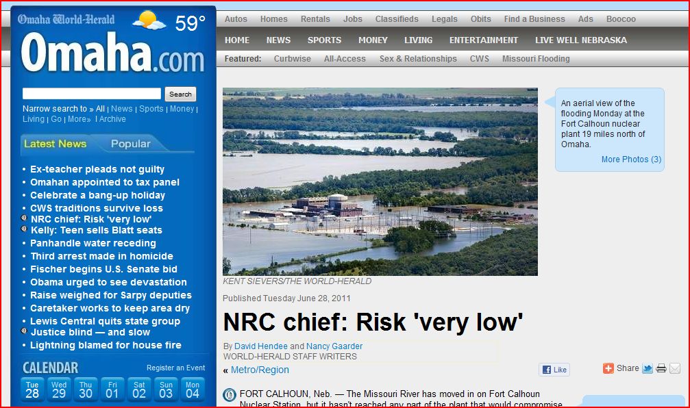
Omaha.com | June 28, 2010 Nuclear Regulatory Commission NRC Chief: Risk 'very low'
Foot traffic restricted by Army Corps near Gavins Point Dam
KDLT Sioux Falls SD | Water Releases Dropping at Garrison Dam in North Dakota


LIVE Web Cam of Gavins Point Dam

Corps: Gavins Point Explosion Rumor ‘Crazy’
The U.S. Army Corps of Engineers official says that a rumor about Gavins Point Dam cracking and being lined with explosives “is crazy.”
A YouTube video surfaced during the weekend from a man making the claim.
“The face of Gavins Point Dam is cracking,” the man says, before explaining that the Corps “or the military” has strung explosives along 25 percent of the structure. The explosives will be detonated this week to relieve pressure on the dam, he claims.
The rumor has circulated widely since the video’s appearance.
“I saw it,” U.S. Army Corps of Engineers Omaha District Commander Col. Bob Ruch said during a conference call Sunday evening. “Whether it’s a joke or a hoax, that’s what the Internet allows. If you want the truth, come to our webpage and sit in on these (conference calls). We’re not stringing explosives on the dam. It’s not cracking. It’s performing as designed.”
Also, Ruch also said during the call that there is a possibility that access to Chief White Crane Recreation Area, located on the east edge of Lake Yankton, could be closed off because of rising waters.
RELATED:
http://www.youtube.com/user/TerralO3

 http://www.kansascity.com/
- 20 people arrested for drunken boating in Missouri
- Flooding closes Amelia Earhart Bridge, part of K-7
- Governor: Missouri faces weeks of potential floods
REAL TIME RADIATION NETWORK
(The following is only a picture of the website - a link)
 ALERT LEVEL = 100 CPM
CPM = Counts Per Minute
From Radiation Network: The numbers represent radiation Counts per Minute, abbreviated CPM, and under normal conditions, quantify the level of background radiation, i.e. environmental radiation from outer space as well as from the earth's crust and air. Depending on your location, your elevation or altitude, and your model of Geiger counter, this background radiation level might average anywhere from 5 to 60 CPM, and while background radiation levels are random, it would be unusual for those levels to exceed 100 CPM. Thus, the "Alert Level" for the National Radiation Map is 100 CPM, so if you see any Monitoring Stations with CPM value above 100, further indicated by an Alert symbol over those stations, it probably means that some radioactive source above and beyond background radiation is responsible.
NOAA Hydrologic - Water Level at Gavins Point Dam, near Ft. Calhoun and Cooper Nuclear Plants

(The following link takes a bit to load all data)
http://water.weather.gov/ahps2/river.php?wfo=oax&wfoid=18705&riverid=203276&view=1%2C1%2C1%2C1%2C1%2C1%2C1%2C1&toggles=10%2C7%2C8%2C2%2C9%2C15%2C6&pt[]=141614&pt[]=144183&pt[]=142396&pt[]=143355&allpoints=143990%2C145585%2C145025%2C145026%2C144876%2C145027%2C143234%2C143184%2C145519%2C145640%2C144217%2C142150%2C142780%2C142853%2C145202%2C141586%2C144582%2C143543%2C144796%2C144098%2C144240%2C141320%2C141614%2C142968%2C144183%2C142574%2C143478%2C142193%2C142760%2C142003%2C142610%2C142396%2C144496%2C147345%2C141899%2C143355%2C142050%2C141570%2C144165%2C143476%2C141703%2C142023%2C144123%2C141863%2C143539%2C143436%2C141917%2C143009%2C142688%2C142640%2C143925%2C143734%2C142729%2C141978%2C143579%2C143348%2C142822&data[]=all&submit=Make+my+River+Page%21#bron1

BLAIR, NEBRASKA NEAR FT. CALHOUN NUCLEAR POWER PLANT

BROWNVILLE, NE - NEAR COOPER NUCLEAR PLANT

RESERVOIR CONTROL CENTER REPORTS
The following is the latest Reservoir Readings on the Upper Missouri River - Sunday June 26, 2011. This report is updated daily. Click on the picture for today's readings in reference to Gavins Point Dam, Ft. Randall Dam in SD, Big Bend Dam in SD, Oahe Dam in SD, Garrison Dam in ND and Fort Peck in Mt.
Link to daily report:
http://www.nwd-mr.usace.army.mil/rcc/reports/showrep.cgi?3MRDTAP7Link to daily report:
June 28, 2011

The Cave's Archive: NW DIVISION OF THE US ARMY CORPS OF ENGINEERS RESERVOIR CONTROL CENTER DAILY REPORT
Link: THE CAVE'S OVERFLOW - Archive of the Cave's Daily Flood of 2011 Updates