DAILY SINCE DECEMBER, 2009
http://www.youtube.com/user/CaveNews?feature=mhum

ALASKA'S HAARP FLUXGATE MAGNETOMETER
http://137.229.36.30/cgi-bin/magnetometer/gak-mag.cgi

EARTHQUAKE UPDATE

Latest Earthquakes Magnitude 2.5 or Greater in the United States and Adjacent Areas and Magnitude 4.5 or Greater in the Rest of the World - Last
Update time = Wed Jul 13 0:00:04 UTC 2011
| MAG | UTC DATE-TIME y/m/d h:m:s | DEPTH km | Region | |
|---|---|---|---|---|
| MAP | 3.1 | 2011/07/12 22:58:45 | 1.9 | SOUTHERN ALASKA |
| MAP | 4.6 | 2011/07/12 22:27:32 | 140.0 | HALMAHERA, INDONESIA |
| MAP | 5.8 | 2011/07/12 21:06:13 | 126.5 | BANDA SEA |
| MAP | 4.7 | 2011/07/12 20:56:38 | 25.5 | OFF THE EAST COAST OF HONSHU, JAPAN |
| MAP | 5.1 | 2011/07/12 20:51:27 | 30.9 | COSTA RICA |
| MAP | 5.0 | 2011/07/12 20:47:11 | 10.0 | NEAR THE EAST COAST OF HONSHU, JAPAN |
| MAP | 5.1 | 2011/07/12 20:18:02 | 59.0 | COSTA RICA |
| MAP | 2.7 | 2011/07/12 20:17:27 | 3.6 | SOUTHERN CALIFORNIA |
| MAP | 2.8 | 2011/07/12 20:16:38 | 4.7 | NORTHERN ALASKA |
| MAP | 5.6 | 2011/07/12 20:11:09 | 62.4 | COSTA RICA |
| MAP | 4.8 | 2011/07/12 19:32:13 | 39.2 | OFF THE EAST COAST OF HONSHU, JAPAN |
| MAP | 3.2 | 2011/07/12 19:12:24 | 95.5 | VIRGIN ISLANDS REGION |
| MAP | 4.9 | 2011/07/12 18:57:09 | 68.7 | HALMAHERA, INDONESIA |
| MAP | 4.8 | 2011/07/12 17:16:02 | 16.6 | KERMADEC ISLANDS REGION |
| MAP | 4.8 | 2011/07/12 16:30:49 | 10.0 | FIJI REGION |
| MAP | 5.2 | 2011/07/12 15:37:25 | 56.1 | NEAR THE EAST COAST OF HONSHU, JAPAN |
| MAP | 4.9 | 2011/07/12 14:49:47 | 65.0 | VANUATU |
| MAP | 4.2 | 2011/07/12 14:46:16 | 53.8 | PAKISTAN |
| MAP | 4.4 | 2011/07/12 13:40:12 | 13.6 | AZERBAIJAN |
| MAP | 2.6 | 2011/07/12 13:25:41 | 13.7 | HAWAII REGION, HAWAII |
| MAP | 4.8 | 2011/07/12 13:17:14 | 33.0 | NEGROS, PHILIPPINES |
| MAP | 3.1 | 2011/07/12 12:06:07 | 52.5 | SOUTHERN ALASKA |
| MAP | 4.7 | 2011/07/12 11:29:25 | 52.9 | NEGROS, PHILIPPINES |
| MAP | 5.1 | 2011/07/12 11:17:10 | 25.8 | TAIWAN |
| MAP | 5.0 | 2011/07/12 10:09:47 | 13.5 | TONGA |
| MAP | 4.7 | 2011/07/12 09:00:01 | 67.4 | NEAR THE EAST COAST OF HONSHU, JAPAN |
| MAP | 5.4 | 2011/07/12 08:56:21 | 52.1 | NEGROS, PHILIPPINES |
| MAP | 2.5 | 2011/07/12 08:08:54 | 9.2 | FOX ISLANDS, ALEUTIAN ISLANDS, ALASKA |
| MAP | 4.8 | 2011/07/12 07:57:19 | 32.0 | NEGROS, PHILIPPINES |
| MAP | 2.6 | 2011/07/12 07:54:30 | 0.3 | NEVADA |
| MAP | 4.6 | 2011/07/12 07:15:10 | 2.4 | NORTHERN ITALY |
| MAP | 4.5 | 2011/07/12 06:53:24 | 7.1 | CENTRAL ITALY |
| MAP | 4.6 | 2011/07/12 06:46:58 | 20.7 | OFF THE EAST COAST OF HONSHU, JAPAN |
| MAP | 4.9 | 2011/07/12 06:12:16 | 98.4 | SOUTH SANDWICH ISLANDS REGION |
| MAP | 2.7 | 2011/07/12 06:10:08 | 19.8 | OFFSHORE OREGON |
| MAP | 4.5 | 2011/07/12 04:14:13 | 193.3 | JUJUY, ARGENTINA |
| MAP | 4.7 | 2011/07/12 04:13:56 | 524.0 | FIJI REGION |
| MAP | 3.0 | 2011/07/12 03:02:55 | 10.0 | BAJA CALIFORNIA, MEXICO |
| MAP | 5.2 | 2011/07/12 00:09:52 | 53.4 | KURIL ISLANDS |

New Madrid Center for Earthquake Research and Information
RECENT CENTRAL STATES EARTHQUAKES
http://folkworm.ceri.memphis.edu/recenteqs/Quakes/quakes0.html
map 1.6 2011/07/11 5 km ( 3 mi) S of New Madrid, MO
map 2.1 2011/07/11 5 km ( 3 mi) WSW of Quitman, AR
map 1.2 2011/07/10 9 km ( 6 mi) SE of Ridgely, TN
map 1.0 2011/07/09 7 km ( 4 mi) WSW of Lepanto, AR
map 1.9 2011/07/09 9 km ( 6 mi) ESE of Guy, AR
SOLAR UPDATE

EASTERN UNREST: An active region emerging over the sun's eastern limb is hurling material high above the stellar surface. NASA's Solar Dynamics Observatory recorded some of the action during the early hours of July 12th:
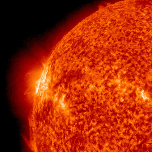

Solar Wind: The solar wind continues to gust near 700 km/s, but has not triggered very much in the way if geomagnetic activity. According to the latest SWPC update, the sudden spike was partly due to a Coronal Hole wind stream and minor incoming CME shock.
Solar Update: The sun consists of several small to fair sized sunspot regions, the largest of which are Sunspots 1247, 1250 and a new alpha spot that rotated onto the eastern limb. This spot was numbered 1251 on Monday. There is a chance for C-Class flares.
MOON UPDATE
