FLOOD DAMAGE IN NORTHERN MISSOURI

ALMOST 600 MILES OF MISSOURI RIVER CLOSED TO BOATS AND BARGES
Jul 13 2011 2:13AM
Associated Press
Coast Guard closes more of the Missouri River
LINCOLN, Neb. (AP) The U.S. Coast Guard is closing more of the flooded Missouri River to boats and barges.
The Coast Guard says it's extending the closure another 160 miles from Leavenworth, Kan., to Glasgow, Mo. The closure went into effect on Monday.
The Coast Guard says it added the stretch after consulting with the U.S. Army Corps of Engineers and the governors of Kansas, Iowa, Nebraska and Missouri.
Nearly 600 miles of the Missouri River are now closed to boat traffic, from Glasgow to near Gavin's Point Dam in Yankton, S.D.
FEMA flood buyouts top $2B since 1993

Devils Lake, ND —JEFFERSON CITY, Mo. (AP) —Since floodwaters ravaged Cedar City and other river towns in 1993, the Federal Emergency Management Agency has spent more than $2 billion to buy 36,707 properties nationwide, according to figures provided to The Associated under an open-records request. Millions more has flowed to those buyouts through the federal Community Development Block Grant program. The money brought an end to more than 3,000 towns and neighborhoods.
RadiationNetwork.com

Updated in real time every minute. This is the first web site where the average citizen (or anyone in the world) can see what radiation levels are anywhere in the USA at any time
Missouri River Dams and River Levels Flood Map

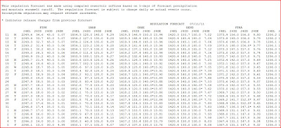
US ARMY CORPS OF ENGINEERS RELEASES NEW FORECAST SCHEDULE OF RELEASE - 6 MAINSTEM MISSOURI BASIN DAMS
NOAA Hydrologic - Water Level at Gavins Point Dam, near Ft. Calhoun and Cooper Nuclear Plants

(The following link takes a bit to load all data)
http://water.weather.gov/ahps2/river.php?wfo=oax&wfoid=18705&riverid=203276&view=1%2C1%2C1%2C1%2C1%2C1%2C1%2C1&toggles=10%2C7%2C8%2C2%2C9%2C15%2C6&pt[]=141614&pt[]=144183&pt[]=142396&pt[]=143355&allpoints=143990%2C145585%2C145025%2C145026%2C144876%2C145027%2C143234%2C143184%2C145519%2C145640%2C144217%2C142150%2C142780%2C142853%2C145202%2C141586%2C144582%2C143543%2C144796%2C144098%2C144240%2C141320%2C141614%2C142968%2C144183%2C142574%2C143478%2C142193%2C142760%2C142003%2C142610%2C142396%2C144496%2C147345%2C141899%2C143355%2C142050%2C141570%2C144165%2C143476%2C141703%2C142023%2C144123%2C141863%2C143539%2C143436%2C141917%2C143009%2C142688%2C142640%2C143925%2C143734%2C142729%2C141978%2C143579%2C143348%2C142822&data[]=all&submit=Make+my+River+Page%21#bron1

BLAIR, NEBRASKA NEAR FT. CALHOUN NUCLEAR POWER PLANT

BROWNVILLE, NE - NEAR COOPER NUCLEAR PLANT

RESERVOIR CONTROL CENTER REPORTS
The following is the latest Reservoir Readings on the Upper Missouri River. This report is updated daily. Click on the picture for today's readings in reference to Gavins Point Dam, Ft. Randall Dam in SD, Big Bend Dam in SD, Oahe Dam in SD, Garrison Dam in ND and Fort Peck in Mt.
Link to daily report:
http://www.nwd-mr.usace.army.mil/rcc/reports/showrep.cgi?3MRDTAP7Link to daily report:
The Cave's Archive: NW DIVISION OF THE US ARMY CORPS OF ENGINEERS RESERVOIR CONTROL CENTER DAILY REPORT


Link: THE CAVE'S OVERFLOW - Archive of the Cave's Daily Flood of 2011 Updates