
Wednesday, July 13, 2011 6:42 pm
WASHINGTON - U.S. senators from the seven states that line the Missouri River said Wednesday they have a new sense of cooperation after a summer of heavy flooding throughout the river basin.
The newly created Missouri River Working Group - comprised of senators from Iowa, Kansas, Missouri, Montana, Nebraska, North Dakota and South Dakota - met for the first time Wednesday. The group pressed officials from the U.S. Army Corps of Engineers on the agency's flexibility, what it is doing to prevent more flooding this summer and preparations for next year's flood season.
No tangible proposals emerged from the closed-door discussions, but the senators agreed that the meeting's most important development was the shared sense of purpose among states that have often squabbled over how to manage the river.
"We'd hoped that by getting all the info at the same time on the basin, that everyone along the river would have a shared concern about the priority of flood control," said Sen. Roy Blunt, a Missouri Republican who formed the working group with his Democratic colleague Sen. Claire McCaskill, along with Sens. Kent Conrad, D-N.D. and John Hoeven, R-N.D. "I think it's safe to say that every member said it was a top priority from the source of the river in Montana to the end of the river in St. Louis."
McCaskill said she had seen rifts between states in the past over how best to manage the river, but that those tensions had dissipated after flooding affected virtually every state along the Missouri River this summer.
"There's a new sense of collaboration about managing the river," she said. "People are willing to put other priorities to one side. We're more united."
Sen. Jon Tester, D-Mont., echoed McCaskill and said the flooding this year "was a record event, off the end of the chart." He said the flooding showed the states that they need to take preparation and cooperation seriously.
Wednesday's meeting included testimony from two U.S. Army Corps of Engineers officials, Gen. John McMahon and Major Gen. William Grissoli. Blunt said McMahon took note that the states were working together.
"He said a meeting of all these states working together is a high note for the Missouri River basin," Blunt said.
The group has not set a date for its next meeting, but it is likely to meet again soon.
http://www.siouxcityjournal.com/news/national/article_845442d7-c824-568b-b50f-ee233d33abb9.html
MORE FLOOD STORIES FROM THE SIOUX CITY JOURNAL
RadiationNetwork.com

Updated in real time every minute. This is the first web site where the average citizen (or anyone in the world) can see what radiation levels are anywhere in the USA at any time
Missouri River Dams and River Levels Flood Map

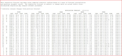
US ARMY CORPS OF ENGINEERS RELEASES NEW FORECAST SCHEDULE OF RELEASE - 6 MAINSTEM MISSOURI BASIN DAMS
NOAA Hydrologic - Water Level at Gavins Point Dam, near Ft. Calhoun and Cooper Nuclear Plants

(The following link takes a bit to load all data)
http://water.weather.gov/ahps2/river.php?wfo=oax&wfoid=18705&riverid=203276&view=1%2C1%2C1%2C1%2C1%2C1%2C1%2C1&toggles=10%2C7%2C8%2C2%2C9%2C15%2C6&pt[]=141614&pt[]=144183&pt[]=142396&pt[]=143355&allpoints=143990%2C145585%2C145025%2C145026%2C144876%2C145027%2C143234%2C143184%2C145519%2C145640%2C144217%2C142150%2C142780%2C142853%2C145202%2C141586%2C144582%2C143543%2C144796%2C144098%2C144240%2C141320%2C141614%2C142968%2C144183%2C142574%2C143478%2C142193%2C142760%2C142003%2C142610%2C142396%2C144496%2C147345%2C141899%2C143355%2C142050%2C141570%2C144165%2C143476%2C141703%2C142023%2C144123%2C141863%2C143539%2C143436%2C141917%2C143009%2C142688%2C142640%2C143925%2C143734%2C142729%2C141978%2C143579%2C143348%2C142822&data[]=all&submit=Make+my+River+Page%21#bron1

BLAIR, NEBRASKA NEAR FT. CALHOUN NUCLEAR POWER PLANT

BROWNVILLE, NE - NEAR COOPER NUCLEAR PLANT

RESERVOIR CONTROL CENTER REPORTS
The following is the latest Reservoir Readings on the Upper Missouri River. This report is updated daily. Click on the picture for today's readings in reference to Gavins Point Dam, Ft. Randall Dam in SD, Big Bend Dam in SD, Oahe Dam in SD, Garrison Dam in ND and Fort Peck in Mt.
Link to daily report:
http://www.nwd-mr.usace.army.mil/rcc/reports/showrep.cgi?3MRDTAP7Link to daily report:
The Cave's Archive: NW DIVISION OF THE US ARMY CORPS OF ENGINEERS RESERVOIR CONTROL CENTER DAILY REPORT


Link: THE CAVE'S OVERFLOW - Archive of the Cave's Daily Flood of 2011 Updates